You are here: Home > Network List > TA - USArray Transportable Network (new EarthScope stations) Stations List
> Station P20A De Beque, CO, USA > Earthquake Result Viewer
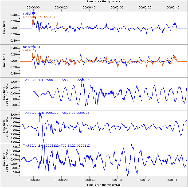
P20A De Beque, CO, USA - Earthquake Result Viewer
*The percent match for this event was below the threshold and hence no stack was calculated.
| Earthquake location: |
Tonga Islands Region |
| Earthquake latitude/longitude: |
-17.3/-171.9 |
| Earthquake time(UTC): |
2008/12/24 (359) 09:11:34 GMT |
| Earthquake Depth: |
9.0 km |
| Earthquake Magnitude: |
5.9 MB, 5.6 MS, 6.0 MW, 6.0 MW |
| Earthquake Catalog/Contributor: |
WHDF/NEIC |
|
| Network: |
TA USArray Transportable Network (new EarthScope stations) |
| Station: |
P20A De Beque, CO, USA |
| Lat/Lon: |
39.50 N/108.39 W |
| Elevation: |
1738 m |
|
| Distance: |
81.8 deg |
| Az: |
44.401 deg |
| Baz: |
239.762 deg |
| Ray Param: |
$rayparam |
*The percent match for this event was below the threshold and hence was not used in the summary stack. |
|
| Radial Match: |
63.798473 % |
| Radial Bump: |
400 |
| Transverse Match: |
57.411827 % |
| Transverse Bump: |
390 |
| SOD ConfigId: |
2658 |
| Insert Time: |
2010-03-06 07:22:08.092 +0000 |
| GWidth: |
2.5 |
| Max Bumps: |
400 |
| Tol: |
0.001 |
|
Signal To Noise
| Channel | StoN | STA | LTA |
| TA:P20A: :BHZ:20081224T09:23:22.099021Z | 3.5618918 | 1.1502378E-6 | 3.229289E-7 |
| TA:P20A: :BHN:20081224T09:23:22.099021Z | 0.83301646 | 4.2837084E-7 | 5.142405E-7 |
| TA:P20A: :BHE:20081224T09:23:22.099021Z | 2.4609177 | 1.2886285E-6 | 5.2363737E-7 |
| Arrivals |
| Ps | |
| PpPs | |
| PsPs/PpSs | |


