You are here: Home > Network List > TA - USArray Transportable Network (new EarthScope stations) Stations List
> Station A36M Sachs Harbour, NT, CAN > Earthquake Result Viewer
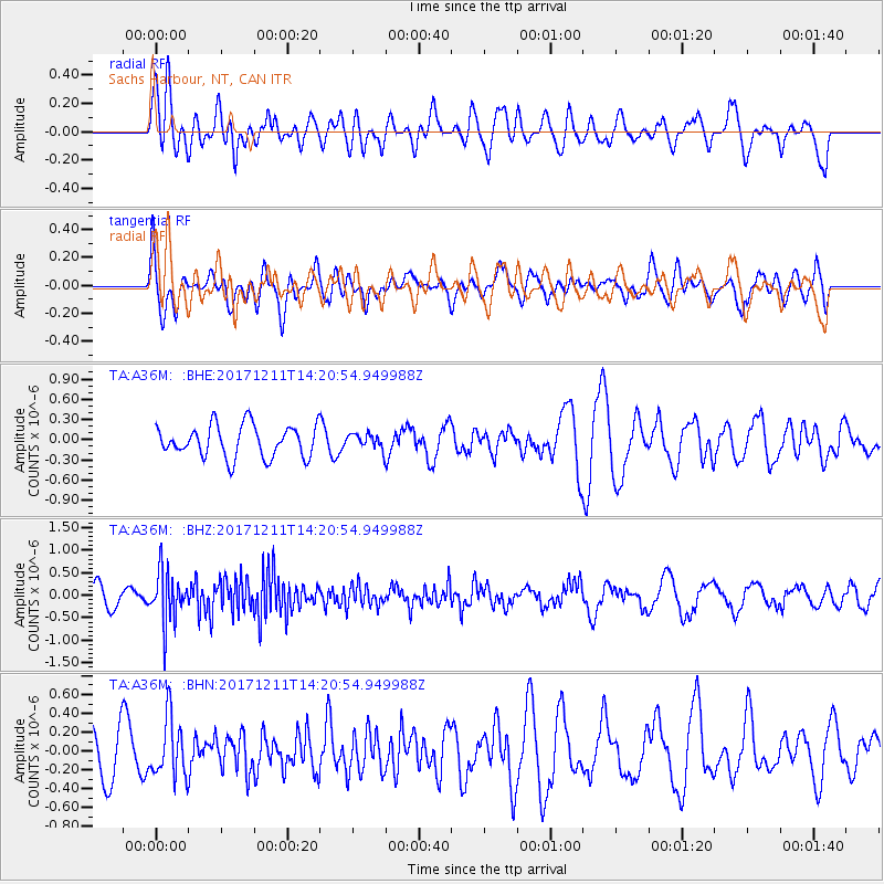
A36M Sachs Harbour, NT, CAN - Earthquake Result Viewer
*The percent match for this event was below the threshold and hence no stack was calculated.
| Earthquake location: |
Iran-Iraq Border Region |
| Earthquake latitude/longitude: |
35.0/45.7 |
| Earthquake time(UTC): |
2017/12/11 (345) 14:09:56 GMT |
| Earthquake Depth: |
12 km |
| Earthquake Magnitude: |
5.3 Mww |
| Earthquake Catalog/Contributor: |
NEIC PDE/us |
|
| Network: |
TA USArray Transportable Network (new EarthScope stations) |
| Station: |
A36M Sachs Harbour, NT, CAN |
| Lat/Lon: |
71.99 N/125.25 W |
| Elevation: |
32 m |
|
| Distance: |
73.1 deg |
| Az: |
357.077 deg |
| Baz: |
7.734 deg |
| Ray Param: |
$rayparam |
*The percent match for this event was below the threshold and hence was not used in the summary stack. |
|
| Radial Match: |
64.590836 % |
| Radial Bump: |
400 |
| Transverse Match: |
44.664352 % |
| Transverse Bump: |
400 |
| SOD ConfigId: |
13570011 |
| Insert Time: |
2019-04-29 10:05:04.803 +0000 |
| GWidth: |
2.5 |
| Max Bumps: |
400 |
| Tol: |
0.001 |
|
Signal To Noise
| Channel | StoN | STA | LTA |
| TA:A36M: :BHZ:20171211T14:20:54.949988Z | 3.229162 | 5.578998E-7 | 1.7276922E-7 |
| TA:A36M: :BHN:20171211T14:20:54.949988Z | 1.607694 | 3.1147877E-7 | 1.9374257E-7 |
| TA:A36M: :BHE:20171211T14:20:54.949988Z | 0.595821 | 1.4220454E-7 | 2.386699E-7 |
| Arrivals |
| Ps | |
| PpPs | |
| PsPs/PpSs | |


