You are here: Home > Network List > TA - USArray Transportable Network (new EarthScope stations) Stations List
> Station J20K Nowitna River, AK, USA > Earthquake Result Viewer
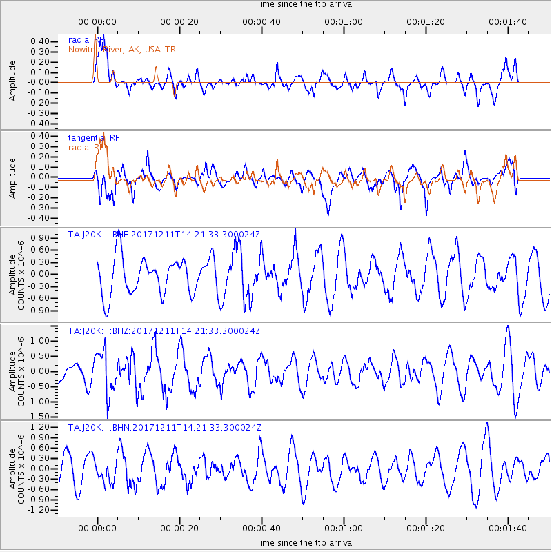
J20K Nowitna River, AK, USA - Earthquake Result Viewer
*The percent match for this event was below the threshold and hence no stack was calculated.
| Earthquake location: |
Iran-Iraq Border Region |
| Earthquake latitude/longitude: |
35.0/45.7 |
| Earthquake time(UTC): |
2017/12/11 (345) 14:09:56 GMT |
| Earthquake Depth: |
12 km |
| Earthquake Magnitude: |
5.3 Mww |
| Earthquake Catalog/Contributor: |
NEIC PDE/us |
|
| Network: |
TA USArray Transportable Network (new EarthScope stations) |
| Station: |
J20K Nowitna River, AK, USA |
| Lat/Lon: |
64.18 N/154.15 W |
| Elevation: |
314 m |
|
| Distance: |
79.9 deg |
| Az: |
8.698 deg |
| Baz: |
343.532 deg |
| Ray Param: |
$rayparam |
*The percent match for this event was below the threshold and hence was not used in the summary stack. |
|
| Radial Match: |
66.37832 % |
| Radial Bump: |
400 |
| Transverse Match: |
74.25712 % |
| Transverse Bump: |
400 |
| SOD ConfigId: |
13570011 |
| Insert Time: |
2019-04-29 10:05:24.631 +0000 |
| GWidth: |
2.5 |
| Max Bumps: |
400 |
| Tol: |
0.001 |
|
Signal To Noise
| Channel | StoN | STA | LTA |
| TA:J20K: :BHZ:20171211T14:21:33.300024Z | 2.3662403 | 6.914928E-7 | 2.922327E-7 |
| TA:J20K: :BHN:20171211T14:21:33.300024Z | 1.1621686 | 3.0790483E-7 | 2.6493987E-7 |
| TA:J20K: :BHE:20171211T14:21:33.300024Z | 1.4267447 | 6.502333E-7 | 4.557461E-7 |
| Arrivals |
| Ps | |
| PpPs | |
| PsPs/PpSs | |


