You are here: Home > Network List > TA - USArray Transportable Network (new EarthScope stations) Stations List
> Station J25K Salcha River, AK, USA > Earthquake Result Viewer
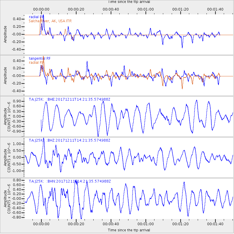
J25K Salcha River, AK, USA - Earthquake Result Viewer
*The percent match for this event was below the threshold and hence no stack was calculated.
| Earthquake location: |
Iran-Iraq Border Region |
| Earthquake latitude/longitude: |
35.0/45.7 |
| Earthquake time(UTC): |
2017/12/11 (345) 14:09:56 GMT |
| Earthquake Depth: |
12 km |
| Earthquake Magnitude: |
5.3 Mww |
| Earthquake Catalog/Contributor: |
NEIC PDE/us |
|
| Network: |
TA USArray Transportable Network (new EarthScope stations) |
| Station: |
J25K Salcha River, AK, USA |
| Lat/Lon: |
64.61 N/145.37 W |
| Elevation: |
949 m |
|
| Distance: |
80.3 deg |
| Az: |
4.828 deg |
| Baz: |
350.776 deg |
| Ray Param: |
$rayparam |
*The percent match for this event was below the threshold and hence was not used in the summary stack. |
|
| Radial Match: |
62.414043 % |
| Radial Bump: |
321 |
| Transverse Match: |
55.04484 % |
| Transverse Bump: |
353 |
| SOD ConfigId: |
13570011 |
| Insert Time: |
2019-04-29 10:05:24.968 +0000 |
| GWidth: |
2.5 |
| Max Bumps: |
400 |
| Tol: |
0.001 |
|
Signal To Noise
| Channel | StoN | STA | LTA |
| TA:J25K: :BHZ:20171211T14:21:35.574988Z | 2.4746614 | 6.228944E-7 | 2.5170894E-7 |
| TA:J25K: :BHN:20171211T14:21:35.574988Z | 1.10634 | 3.7289522E-7 | 3.37053E-7 |
| TA:J25K: :BHE:20171211T14:21:35.574988Z | 1.403952 | 6.2469485E-7 | 4.449546E-7 |
| Arrivals |
| Ps | |
| PpPs | |
| PsPs/PpSs | |


