You are here: Home > Network List > TA - USArray Transportable Network (new EarthScope stations) Stations List
> Station P20A De Beque, CO, USA > Earthquake Result Viewer
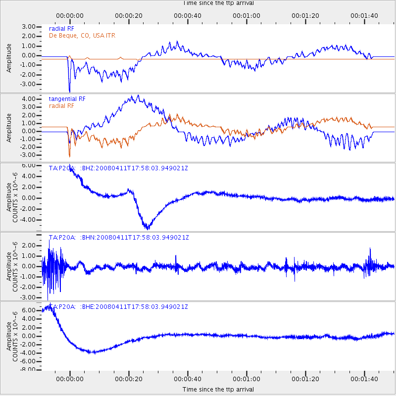
P20A De Beque, CO, USA - Earthquake Result Viewer
*The percent match for this event was below the threshold and hence no stack was calculated.
| Earthquake location: |
Loyalty Islands |
| Earthquake latitude/longitude: |
-20.4/168.8 |
| Earthquake time(UTC): |
2008/04/11 (102) 17:45:05 GMT |
| Earthquake Depth: |
35 km |
| Earthquake Magnitude: |
5.7 MB, 5.9 MS, 6.0 MW, 6.0 MW |
| Earthquake Catalog/Contributor: |
WHDF/NEIC |
|
| Network: |
TA USArray Transportable Network (new EarthScope stations) |
| Station: |
P20A De Beque, CO, USA |
| Lat/Lon: |
39.50 N/108.39 W |
| Elevation: |
1738 m |
|
| Distance: |
97.4 deg |
| Az: |
50.716 deg |
| Baz: |
249.782 deg |
| Ray Param: |
$rayparam |
*The percent match for this event was below the threshold and hence was not used in the summary stack. |
|
| Radial Match: |
46.22175 % |
| Radial Bump: |
400 |
| Transverse Match: |
50.21733 % |
| Transverse Bump: |
400 |
| SOD ConfigId: |
2504 |
| Insert Time: |
2010-03-06 07:22:40.477 +0000 |
| GWidth: |
2.5 |
| Max Bumps: |
400 |
| Tol: |
0.001 |
|
Signal To Noise
| Channel | StoN | STA | LTA |
| TA:P20A: :BHN:20080411T17:58:03.949021Z | 0.5004639 | 2.7610875E-7 | 5.517056E-7 |
| TA:P20A: :BHE:20080411T17:58:03.949021Z | 1.6642804 | 4.706067E-6 | 2.8276888E-6 |
| TA:P20A: :BHZ:20080411T17:58:03.949021Z | 1.6294852 | 3.1826817E-6 | 1.9531822E-6 |
| Arrivals |
| Ps | |
| PpPs | |
| PsPs/PpSs | |


