You are here: Home > Network List > TA - USArray Transportable Network (new EarthScope stations) Stations List
> Station P20A De Beque, CO, USA > Earthquake Result Viewer
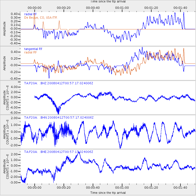
P20A De Beque, CO, USA - Earthquake Result Viewer
*The percent match for this event was below the threshold and hence no stack was calculated.
| Earthquake location: |
Kuril Islands |
| Earthquake latitude/longitude: |
43.9/147.5 |
| Earthquake time(UTC): |
2008/04/12 (103) 00:46:28 GMT |
| Earthquake Depth: |
64 km |
| Earthquake Magnitude: |
5.7 MB |
| Earthquake Catalog/Contributor: |
WHDF/NEIC |
|
| Network: |
TA USArray Transportable Network (new EarthScope stations) |
| Station: |
P20A De Beque, CO, USA |
| Lat/Lon: |
39.50 N/108.39 W |
| Elevation: |
1738 m |
|
| Distance: |
72.5 deg |
| Az: |
51.899 deg |
| Baz: |
312.653 deg |
| Ray Param: |
$rayparam |
*The percent match for this event was below the threshold and hence was not used in the summary stack. |
|
| Radial Match: |
32.93538 % |
| Radial Bump: |
400 |
| Transverse Match: |
33.764465 % |
| Transverse Bump: |
400 |
| SOD ConfigId: |
2504 |
| Insert Time: |
2010-03-06 07:22:42.194 +0000 |
| GWidth: |
2.5 |
| Max Bumps: |
400 |
| Tol: |
0.001 |
|
Signal To Noise
| Channel | StoN | STA | LTA |
| TA:P20A: :BHN:20080412T00:57:17.024006Z | 0.88030237 | 7.654124E-7 | 8.694881E-7 |
| TA:P20A: :BHE:20080412T00:57:17.024006Z | 0.706762 | 1.4233572E-6 | 2.013913E-6 |
| TA:P20A: :BHZ:20080412T00:57:17.024006Z | 1.1039075 | 1.968756E-6 | 1.7834429E-6 |
| Arrivals |
| Ps | |
| PpPs | |
| PsPs/PpSs | |


