You are here: Home > Network List > TA - USArray Transportable Network (new EarthScope stations) Stations List
> Station P20A De Beque, CO, USA > Earthquake Result Viewer
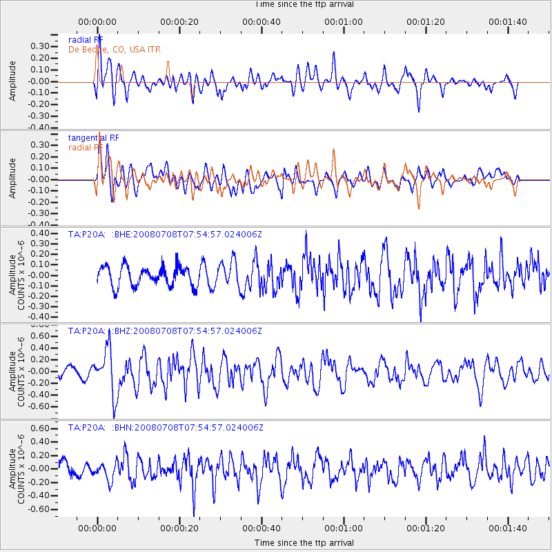
P20A De Beque, CO, USA - Earthquake Result Viewer
*The percent match for this event was below the threshold and hence no stack was calculated.
| Earthquake location: |
Ryukyu Islands, Japan |
| Earthquake latitude/longitude: |
27.5/128.3 |
| Earthquake time(UTC): |
2008/07/08 (190) 07:42:10 GMT |
| Earthquake Depth: |
43 km |
| Earthquake Magnitude: |
6.0 MB, 5.5 MS, 6.0 MW, 6.0 MW |
| Earthquake Catalog/Contributor: |
WHDF/NEIC |
|
| Network: |
TA USArray Transportable Network (new EarthScope stations) |
| Station: |
P20A De Beque, CO, USA |
| Lat/Lon: |
39.50 N/108.39 W |
| Elevation: |
1738 m |
|
| Distance: |
94.9 deg |
| Az: |
40.485 deg |
| Baz: |
311.827 deg |
| Ray Param: |
$rayparam |
*The percent match for this event was below the threshold and hence was not used in the summary stack. |
|
| Radial Match: |
65.093254 % |
| Radial Bump: |
400 |
| Transverse Match: |
63.596897 % |
| Transverse Bump: |
400 |
| SOD ConfigId: |
2504 |
| Insert Time: |
2010-03-06 07:22:54.834 +0000 |
| GWidth: |
2.5 |
| Max Bumps: |
400 |
| Tol: |
0.001 |
|
Signal To Noise
| Channel | StoN | STA | LTA |
| TA:P20A: :BHZ:20080708T07:54:57.024006Z | 3.7302535 | 4.0117055E-7 | 1.0754512E-7 |
| TA:P20A: :BHN:20080708T07:54:57.024006Z | 1.2402576 | 1.3561322E-7 | 1.0934278E-7 |
| TA:P20A: :BHE:20080708T07:54:57.024006Z | 1.3538231 | 1.2307207E-7 | 9.0907065E-8 |
| Arrivals |
| Ps | |
| PpPs | |
| PsPs/PpSs | |


