You are here: Home > Network List > TA - USArray Transportable Network (new EarthScope stations) Stations List
> Station Q22A Crested Butte, Gunnison, CO, USA > Earthquake Result Viewer
Q22A Crested Butte, Gunnison, CO, USA - Earthquake Result Viewer
| Earthquake location: |
Kermadec Islands Region |
| Earthquake latitude/longitude: |
-31.5/-178.8 |
| Earthquake time(UTC): |
2009/05/16 (136) 00:53:52 GMT |
| Earthquake Depth: |
55 km |
| Earthquake Magnitude: |
6.1 MB, 6.5 MW, 6.3 MW |
| Earthquake Catalog/Contributor: |
WHDF/NEIC |
|
| Network: |
TA USArray Transportable Network (new EarthScope stations) |
| Station: |
Q22A Crested Butte, Gunnison, CO, USA |
| Lat/Lon: |
38.86 N/106.91 W |
| Elevation: |
2727 m |
|
| Distance: |
96.8 deg |
| Az: |
48.348 deg |
| Baz: |
234.822 deg |
| Ray Param: |
0.040381666 |
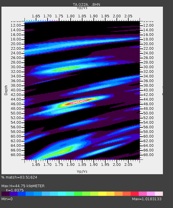
| Estimated Moho Depth: |
44.75 km |
| Estimated Crust Vp/Vs: |
1.84 |
| Assumed Crust Vp: |
6.306 km/s |
| Estimated Crust Vs: |
3.432 km/s |
| Estimated Crust Poisson's Ratio: |
0.29 |
|
| Radial Match: |
83.51624 % |
| Radial Bump: |
400 |
| Transverse Match: |
67.89146 % |
| Transverse Bump: |
400 |
| SOD ConfigId: |
2760 |
| Insert Time: |
2010-03-06 07:23:09.211 +0000 |
| GWidth: |
2.5 |
| Max Bumps: |
400 |
| Tol: |
0.001 |
|

Signal To Noise
| Channel | StoN | STA | LTA |
| TA:Q22A: :BHN:20090516T01:06:46.00001Z | 4.9600334 | 4.856638E-7 | 9.791544E-8 |
| TA:Q22A: :BHE:20090516T01:06:46.00001Z | 1.4579638 | 1.0376818E-7 | 7.117335E-8 |
| TA:Q22A: :BHZ:20090516T01:06:46.00001Z | 2.5162199 | 1.567937E-7 | 6.23132E-8 |
| Arrivals |
| Ps | 6.1 SECOND |
| PpPs | 20 SECOND |
| PsPs/PpSs | 26 SECOND |


