You are here: Home > Network List > UW - Pacific Northwest Regional Seismic Network Stations List
> Station UMAT Pilot Rock, OR, USA > Earthquake Result Viewer
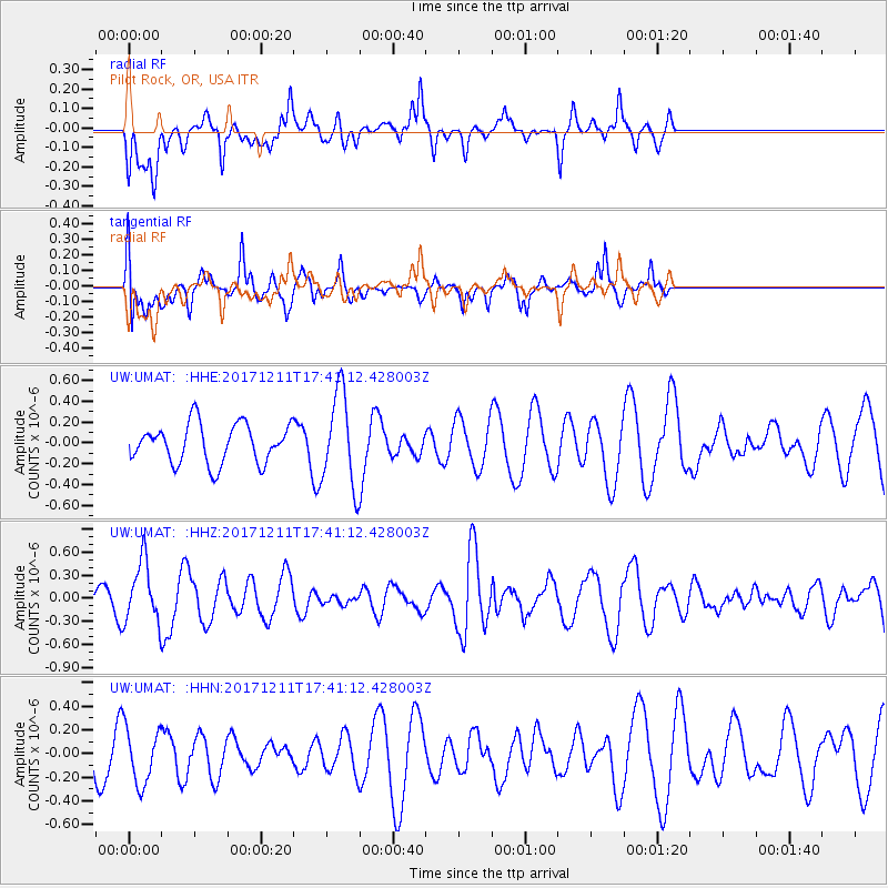
UMAT Pilot Rock, OR, USA - Earthquake Result Viewer
*The percent match for this event was below the threshold and hence no stack was calculated.
| Earthquake location: |
Vanuatu Islands |
| Earthquake latitude/longitude: |
-14.4/167.5 |
| Earthquake time(UTC): |
2017/12/11 (345) 17:29:10 GMT |
| Earthquake Depth: |
187 km |
| Earthquake Magnitude: |
5.6 Mww |
| Earthquake Catalog/Contributor: |
NEIC PDE/us |
|
| Network: |
UW Pacific Northwest Regional Seismic Network |
| Station: |
UMAT Pilot Rock, OR, USA |
| Lat/Lon: |
45.29 N/118.96 W |
| Elevation: |
1318 m |
|
| Distance: |
88.9 deg |
| Az: |
42.629 deg |
| Baz: |
248.413 deg |
| Ray Param: |
$rayparam |
*The percent match for this event was below the threshold and hence was not used in the summary stack. |
|
| Radial Match: |
42.26436 % |
| Radial Bump: |
369 |
| Transverse Match: |
58.787807 % |
| Transverse Bump: |
383 |
| SOD ConfigId: |
13570011 |
| Insert Time: |
2019-04-29 10:11:04.119 +0000 |
| GWidth: |
2.5 |
| Max Bumps: |
400 |
| Tol: |
0.001 |
|
Signal To Noise
| Channel | StoN | STA | LTA |
| UW:UMAT: :HHZ:20171211T17:41:12.428003Z | 2.567406 | 4.0068815E-7 | 1.560673E-7 |
| UW:UMAT: :HHN:20171211T17:41:12.428003Z | 1.205652 | 2.3163992E-7 | 1.9212833E-7 |
| UW:UMAT: :HHE:20171211T17:41:12.428003Z | 2.4132369 | 4.5241268E-7 | 1.8747131E-7 |
| Arrivals |
| Ps | |
| PpPs | |
| PsPs/PpSs | |


