You are here: Home > Network List > TA - USArray Transportable Network (new EarthScope stations) Stations List
> Station Q22A Crested Butte, Gunnison, CO, USA > Earthquake Result Viewer
Q22A Crested Butte, Gunnison, CO, USA - Earthquake Result Viewer

| Earthquake location: |
Costa Rica |
| Earthquake latitude/longitude: |
10.2/-84.2 |
| Earthquake time(UTC): |
2009/01/08 (008) 19:21:35 GMT |
| Earthquake Depth: |
14 km |
| Earthquake Magnitude: |
5.7 MB, 6.0 MS, 6.1 MW, 6.1 MW |
| Earthquake Catalog/Contributor: |
WHDF/NEIC |
|
| Network: |
TA USArray Transportable Network (new EarthScope stations) |
| Station: |
Q22A Crested Butte, Gunnison, CO, USA |
| Lat/Lon: |
38.86 N/106.91 W |
| Elevation: |
2727 m |
|
| Distance: |
35.1 deg |
| Az: |
328.346 deg |
| Baz: |
138.564 deg |
| Ray Param: |
0.07741201 |
| Estimated Moho Depth: |
47.75 km |
| Estimated Crust Vp/Vs: |
1.76 |
| Assumed Crust Vp: |
6.306 km/s |
| Estimated Crust Vs: |
3.573 km/s |
| Estimated Crust Poisson's Ratio: |
0.26 |
|
| Radial Match: |
83.62839 % |
| Radial Bump: |
334 |
| Transverse Match: |
56.660904 % |
| Transverse Bump: |
400 |
| SOD ConfigId: |
2834 |
| Insert Time: |
2010-03-06 07:24:15.114 +0000 |
| GWidth: |
2.5 |
| Max Bumps: |
400 |
| Tol: |
0.001 |
|
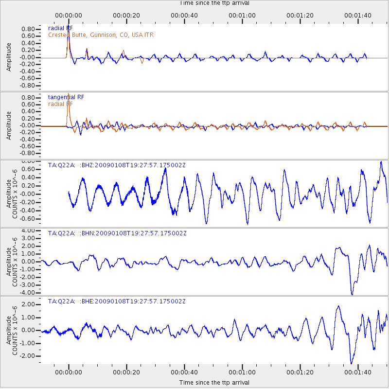
Signal To Noise
| Channel | StoN | STA | LTA |
| TA:Q22A: :BHN:20090108T19:27:57.175002Z | 1.8055248 | 4.6408954E-7 | 2.5703858E-7 |
| TA:Q22A: :BHE:20090108T19:27:57.175002Z | 2.1089172 | 2.9704586E-7 | 1.4085231E-7 |
| TA:Q22A: :BHZ:20090108T19:27:57.175002Z | 1.5873338 | 3.0073429E-7 | 1.8945875E-7 |
| Arrivals |
| Ps | 6.2 SECOND |
| PpPs | 19 SECOND |
| PsPs/PpSs | 26 SECOND |


