You are here: Home > Network List > TA - USArray Transportable Network (new EarthScope stations) Stations List
> Station Q22A Crested Butte, Gunnison, CO, USA > Earthquake Result Viewer
Q22A Crested Butte, Gunnison, CO, USA - Earthquake Result Viewer
| Earthquake location: |
Samoa Islands Region |
| Earthquake latitude/longitude: |
-15.2/-172.6 |
| Earthquake time(UTC): |
2009/08/30 (242) 14:51:32 GMT |
| Earthquake Depth: |
11 km |
| Earthquake Magnitude: |
6.4 MB, 6.3 MS, 6.6 MW, 6.6 MW |
| Earthquake Catalog/Contributor: |
WHDF/NEIC |
|
| Network: |
TA USArray Transportable Network (new EarthScope stations) |
| Station: |
Q22A Crested Butte, Gunnison, CO, USA |
| Lat/Lon: |
38.86 N/106.91 W |
| Elevation: |
2727 m |
|
| Distance: |
81.5 deg |
| Az: |
45.988 deg |
| Baz: |
242.785 deg |
| Ray Param: |
0.0475304 |
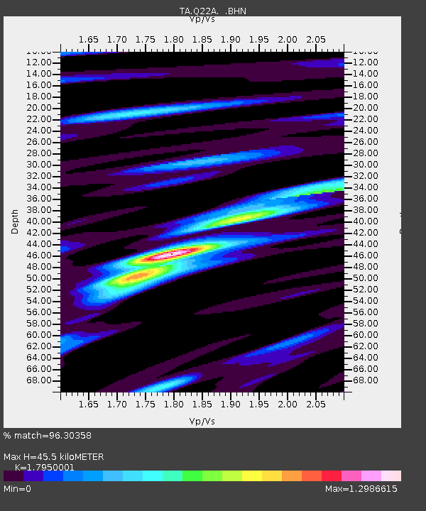
| Estimated Moho Depth: |
45.5 km |
| Estimated Crust Vp/Vs: |
1.80 |
| Assumed Crust Vp: |
6.306 km/s |
| Estimated Crust Vs: |
3.513 km/s |
| Estimated Crust Poisson's Ratio: |
0.27 |
|
| Radial Match: |
96.30358 % |
| Radial Bump: |
392 |
| Transverse Match: |
89.35734 % |
| Transverse Bump: |
400 |
| SOD ConfigId: |
2622 |
| Insert Time: |
2010-03-06 07:24:36.274 +0000 |
| GWidth: |
2.5 |
| Max Bumps: |
400 |
| Tol: |
0.001 |
|

Signal To Noise
| Channel | StoN | STA | LTA |
| TA:Q22A: :BHN:20090830T15:03:18.824021Z | 63.57918 | 3.0646443E-6 | 4.8202008E-8 |
| TA:Q22A: :BHE:20090830T15:03:18.824021Z | 6.736672 | 5.828061E-7 | 8.651246E-8 |
| TA:Q22A: :BHZ:20090830T15:03:18.824021Z | 9.622792 | 9.727036E-7 | 1.01083295E-7 |
| Arrivals |
| Ps | 5.9 SECOND |
| PpPs | 20 SECOND |
| PsPs/PpSs | 26 SECOND |


