You are here: Home > Network List > II - Global Seismograph Network (GSN - IRIS/IDA) Stations List
> Station WRAB Tennant Creek, NT, Australia > Earthquake Result Viewer
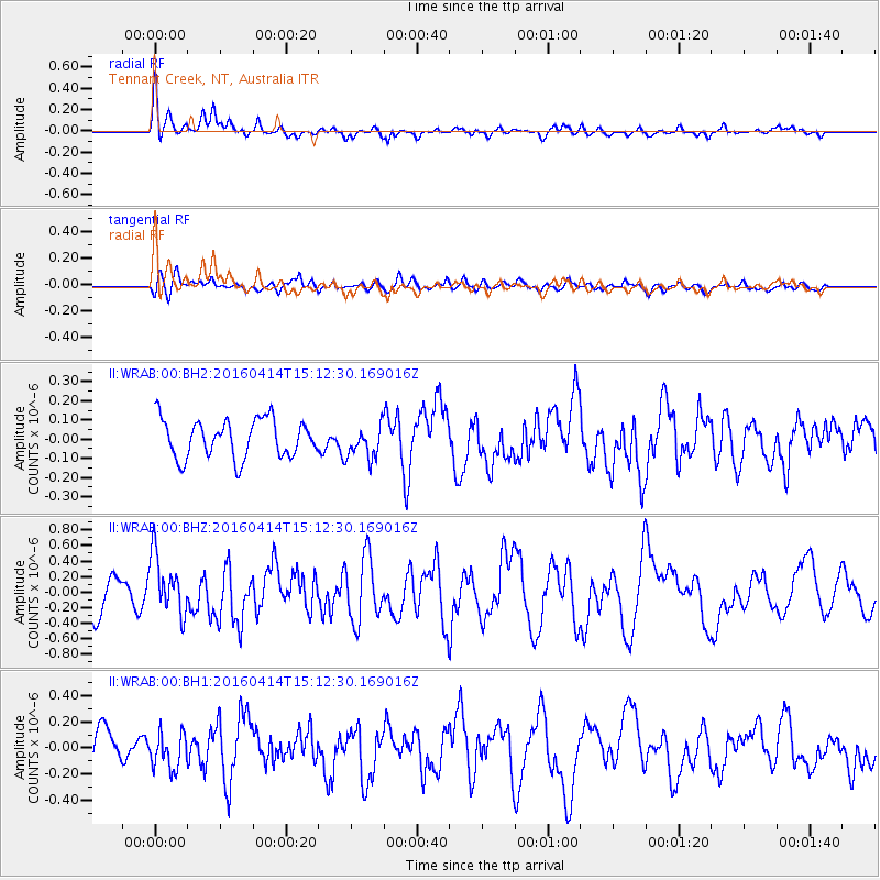
WRAB Tennant Creek, NT, Australia - Earthquake Result Viewer
*The percent match for this event was below the threshold and hence no stack was calculated.
| Earthquake location: |
Kyushu, Japan |
| Earthquake latitude/longitude: |
32.7/130.7 |
| Earthquake time(UTC): |
2016/04/14 (105) 15:03:46 GMT |
| Earthquake Depth: |
1.3 km |
| Earthquake Magnitude: |
5.9 MWB |
| Earthquake Catalog/Contributor: |
NEIC PDE/NEIC COMCAT |
|
| Network: |
II Global Seismograph Network (GSN - IRIS/IDA) |
| Station: |
WRAB Tennant Creek, NT, Australia |
| Lat/Lon: |
19.93 S/134.36 E |
| Elevation: |
366 m |
|
| Distance: |
52.5 deg |
| Az: |
175.687 deg |
| Baz: |
356.138 deg |
| Ray Param: |
$rayparam |
*The percent match for this event was below the threshold and hence was not used in the summary stack. |
|
| Radial Match: |
72.419945 % |
| Radial Bump: |
400 |
| Transverse Match: |
42.290985 % |
| Transverse Bump: |
400 |
| SOD ConfigId: |
1475611 |
| Insert Time: |
2016-04-28 15:06:56.843 +0000 |
| GWidth: |
2.5 |
| Max Bumps: |
400 |
| Tol: |
0.001 |
|
Signal To Noise
| Channel | StoN | STA | LTA |
| II:WRAB:00:BHZ:20160414T15:12:30.169016Z | 1.9501722 | 3.8022313E-7 | 1.9496902E-7 |
| II:WRAB:00:BH1:20160414T15:12:30.169016Z | 1.0316302 | 1.3609065E-7 | 1.3191806E-7 |
| II:WRAB:00:BH2:20160414T15:12:30.169016Z | 0.8620794 | 8.528159E-8 | 9.892545E-8 |
| Arrivals |
| Ps | |
| PpPs | |
| PsPs/PpSs | |


