You are here: Home > Network List > TA - USArray Transportable Network (new EarthScope stations) Stations List
> Station B18K Kokolik River, AK, USA > Earthquake Result Viewer
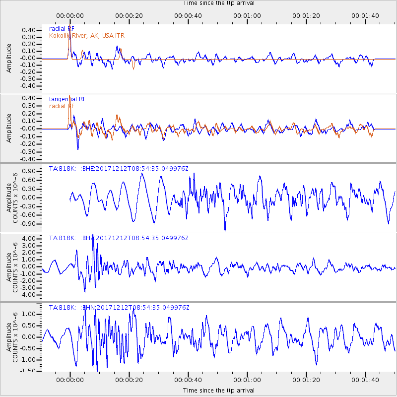
B18K Kokolik River, AK, USA - Earthquake Result Viewer
*The percent match for this event was below the threshold and hence no stack was calculated.
| Earthquake location: |
Northern And Central Iran |
| Earthquake latitude/longitude: |
30.7/57.3 |
| Earthquake time(UTC): |
2017/12/12 (346) 08:43:17 GMT |
| Earthquake Depth: |
10 km |
| Earthquake Magnitude: |
6.0 Mww |
| Earthquake Catalog/Contributor: |
NEIC PDE/us |
|
| Network: |
TA USArray Transportable Network (new EarthScope stations) |
| Station: |
B18K Kokolik River, AK, USA |
| Lat/Lon: |
69.36 N/161.80 W |
| Elevation: |
222 m |
|
| Distance: |
76.2 deg |
| Az: |
13.301 deg |
| Baz: |
326.02 deg |
| Ray Param: |
$rayparam |
*The percent match for this event was below the threshold and hence was not used in the summary stack. |
|
| Radial Match: |
66.1718 % |
| Radial Bump: |
390 |
| Transverse Match: |
58.37027 % |
| Transverse Bump: |
400 |
| SOD ConfigId: |
13570011 |
| Insert Time: |
2019-04-29 10:22:11.907 +0000 |
| GWidth: |
2.5 |
| Max Bumps: |
400 |
| Tol: |
0.001 |
|
Signal To Noise
| Channel | StoN | STA | LTA |
| TA:B18K: :BHZ:20171212T08:54:35.049976Z | 3.1065128 | 1.1738724E-6 | 3.7787467E-7 |
| TA:B18K: :BHN:20171212T08:54:35.049976Z | 3.369915 | 6.2069245E-7 | 1.8418638E-7 |
| TA:B18K: :BHE:20171212T08:54:35.049976Z | 1.2010099 | 4.4569245E-7 | 3.7109808E-7 |
| Arrivals |
| Ps | |
| PpPs | |
| PsPs/PpSs | |


