You are here: Home > Network List > TA - USArray Transportable Network (new EarthScope stations) Stations List
> Station TOLK Toolik Lake Research Station, AK, USA > Earthquake Result Viewer
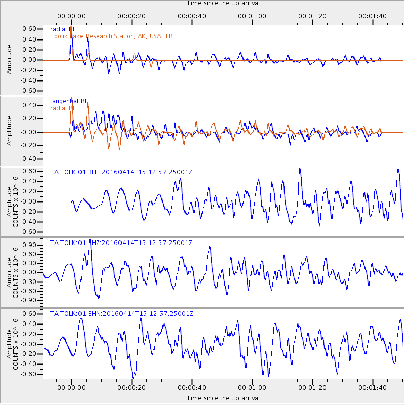
TOLK Toolik Lake Research Station, AK, USA - Earthquake Result Viewer
*The percent match for this event was below the threshold and hence no stack was calculated.
| Earthquake location: |
Kyushu, Japan |
| Earthquake latitude/longitude: |
32.7/130.7 |
| Earthquake time(UTC): |
2016/04/14 (105) 15:03:46 GMT |
| Earthquake Depth: |
1.3 km |
| Earthquake Magnitude: |
5.9 MWB |
| Earthquake Catalog/Contributor: |
NEIC PDE/NEIC COMCAT |
|
| Network: |
TA USArray Transportable Network (new EarthScope stations) |
| Station: |
TOLK Toolik Lake Research Station, AK, USA |
| Lat/Lon: |
68.64 N/149.57 W |
| Elevation: |
760 m |
|
| Distance: |
56.2 deg |
| Az: |
25.7 deg |
| Baz: |
273.932 deg |
| Ray Param: |
$rayparam |
*The percent match for this event was below the threshold and hence was not used in the summary stack. |
|
| Radial Match: |
77.30583 % |
| Radial Bump: |
400 |
| Transverse Match: |
57.939034 % |
| Transverse Bump: |
400 |
| SOD ConfigId: |
1475611 |
| Insert Time: |
2016-04-28 15:12:33.731 +0000 |
| GWidth: |
2.5 |
| Max Bumps: |
400 |
| Tol: |
0.001 |
|
Signal To Noise
| Channel | StoN | STA | LTA |
| TA:TOLK:01:BHZ:20160414T15:12:57.25001Z | 3.0371244 | 3.8194602E-7 | 1.257591E-7 |
| TA:TOLK:01:BHN:20160414T15:12:57.25001Z | 2.0579846 | 2.8218213E-7 | 1.3711576E-7 |
| TA:TOLK:01:BHE:20160414T15:12:57.25001Z | 1.402893 | 2.0557593E-7 | 1.4653715E-7 |
| Arrivals |
| Ps | |
| PpPs | |
| PsPs/PpSs | |


