You are here: Home > Network List > TA - USArray Transportable Network (new EarthScope stations) Stations List
> Station F26K Sheenjek River, AK, USA > Earthquake Result Viewer
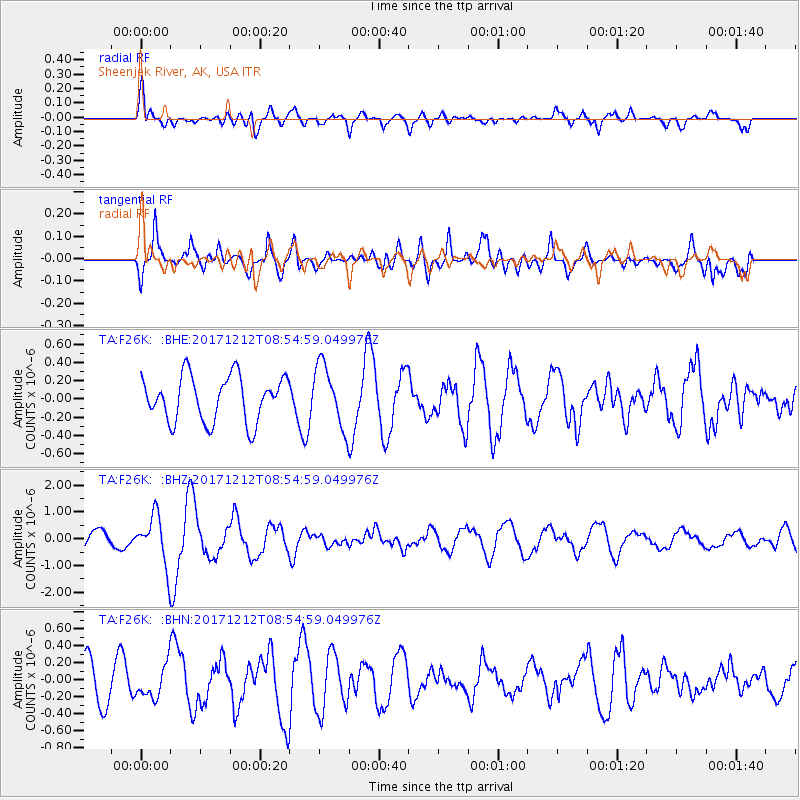
F26K Sheenjek River, AK, USA - Earthquake Result Viewer
*The percent match for this event was below the threshold and hence no stack was calculated.
| Earthquake location: |
Northern And Central Iran |
| Earthquake latitude/longitude: |
30.7/57.3 |
| Earthquake time(UTC): |
2017/12/12 (346) 08:43:17 GMT |
| Earthquake Depth: |
10 km |
| Earthquake Magnitude: |
6.0 Mww |
| Earthquake Catalog/Contributor: |
NEIC PDE/us |
|
| Network: |
TA USArray Transportable Network (new EarthScope stations) |
| Station: |
F26K Sheenjek River, AK, USA |
| Lat/Lon: |
67.69 N/144.15 W |
| Elevation: |
683 m |
|
| Distance: |
80.6 deg |
| Az: |
8.123 deg |
| Baz: |
341.413 deg |
| Ray Param: |
$rayparam |
*The percent match for this event was below the threshold and hence was not used in the summary stack. |
|
| Radial Match: |
58.280388 % |
| Radial Bump: |
400 |
| Transverse Match: |
65.89341 % |
| Transverse Bump: |
400 |
| SOD ConfigId: |
13570011 |
| Insert Time: |
2019-04-29 10:22:44.641 +0000 |
| GWidth: |
2.5 |
| Max Bumps: |
400 |
| Tol: |
0.001 |
|
Signal To Noise
| Channel | StoN | STA | LTA |
| TA:F26K: :BHZ:20171212T08:54:59.049976Z | 3.3030953 | 9.079737E-7 | 2.748857E-7 |
| TA:F26K: :BHN:20171212T08:54:59.049976Z | 0.61622983 | 1.9042348E-7 | 3.0901373E-7 |
| TA:F26K: :BHE:20171212T08:54:59.049976Z | 1.3804616 | 3.422518E-7 | 2.479256E-7 |
| Arrivals |
| Ps | |
| PpPs | |
| PsPs/PpSs | |


