You are here: Home > Network List > US - United States National Seismic Network Stations List
> Station MNTX Cornudas Mountains, Texas, USA > Earthquake Result Viewer
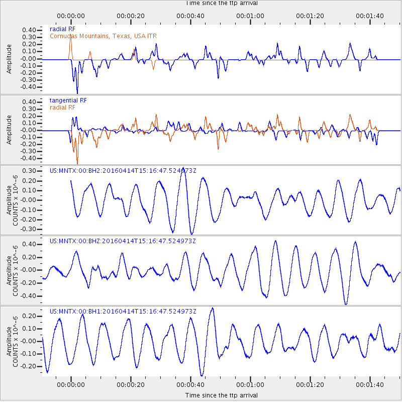
MNTX Cornudas Mountains, Texas, USA - Earthquake Result Viewer
*The percent match for this event was below the threshold and hence no stack was calculated.
| Earthquake location: |
Kyushu, Japan |
| Earthquake latitude/longitude: |
32.7/130.7 |
| Earthquake time(UTC): |
2016/04/14 (105) 15:03:46 GMT |
| Earthquake Depth: |
1.3 km |
| Earthquake Magnitude: |
5.9 MWB |
| Earthquake Catalog/Contributor: |
NEIC PDE/NEIC COMCAT |
|
| Network: |
US United States National Seismic Network |
| Station: |
MNTX Cornudas Mountains, Texas, USA |
| Lat/Lon: |
31.70 N/105.38 W |
| Elevation: |
404 m |
|
| Distance: |
96.8 deg |
| Az: |
45.45 deg |
| Baz: |
315.202 deg |
| Ray Param: |
$rayparam |
*The percent match for this event was below the threshold and hence was not used in the summary stack. |
|
| Radial Match: |
73.61878 % |
| Radial Bump: |
400 |
| Transverse Match: |
44.14174 % |
| Transverse Bump: |
400 |
| SOD ConfigId: |
1475611 |
| Insert Time: |
2016-04-28 15:14:57.747 +0000 |
| GWidth: |
2.5 |
| Max Bumps: |
400 |
| Tol: |
0.001 |
|
Signal To Noise
| Channel | StoN | STA | LTA |
| US:MNTX:00:BHZ:20160414T15:16:47.524973Z | 1.1739289 | 1.642898E-7 | 1.3994868E-7 |
| US:MNTX:00:BH1:20160414T15:16:47.524973Z | 0.7266184 | 1.5296416E-7 | 2.1051511E-7 |
| US:MNTX:00:BH2:20160414T15:16:47.524973Z | 1.9072313 | 2.0477441E-7 | 1.0736737E-7 |
| Arrivals |
| Ps | |
| PpPs | |
| PsPs/PpSs | |


