You are here: Home > Network List > AK - Alaska Regional Network Stations List
> Station CUT Chulitna, AK, USA > Earthquake Result Viewer
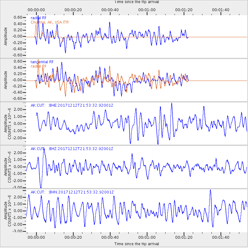
CUT Chulitna, AK, USA - Earthquake Result Viewer
*The percent match for this event was below the threshold and hence no stack was calculated.
| Earthquake location: |
Northern And Central Iran |
| Earthquake latitude/longitude: |
30.8/57.3 |
| Earthquake time(UTC): |
2017/12/12 (346) 21:41:31 GMT |
| Earthquake Depth: |
8.0 km |
| Earthquake Magnitude: |
6.0 Mww |
| Earthquake Catalog/Contributor: |
NEIC PDE/us |
|
| Network: |
AK Alaska Regional Network |
| Station: |
CUT Chulitna, AK, USA |
| Lat/Lon: |
62.41 N/150.26 W |
| Elevation: |
574 m |
|
| Distance: |
84.5 deg |
| Az: |
12.496 deg |
| Baz: |
336.439 deg |
| Ray Param: |
$rayparam |
*The percent match for this event was below the threshold and hence was not used in the summary stack. |
|
| Radial Match: |
43.734642 % |
| Radial Bump: |
400 |
| Transverse Match: |
48.480255 % |
| Transverse Bump: |
400 |
| SOD ConfigId: |
13570011 |
| Insert Time: |
2019-04-29 10:24:46.841 +0000 |
| GWidth: |
2.5 |
| Max Bumps: |
400 |
| Tol: |
0.001 |
|
Signal To Noise
| Channel | StoN | STA | LTA |
| AK:CUT: :BHZ:20171212T21:53:32.92001Z | 3.7062411 | 1.6550078E-6 | 4.4654618E-7 |
| AK:CUT: :BHN:20171212T21:53:32.92001Z | 1.0558378 | 9.92887E-7 | 9.403783E-7 |
| AK:CUT: :BHE:20171212T21:53:32.92001Z | 1.2405876 | 9.2215964E-7 | 7.433249E-7 |
| Arrivals |
| Ps | |
| PpPs | |
| PsPs/PpSs | |


