You are here: Home > Network List > TA - USArray Transportable Network (new EarthScope stations) Stations List
> Station Q22A Crested Butte, Gunnison, CO, USA > Earthquake Result Viewer
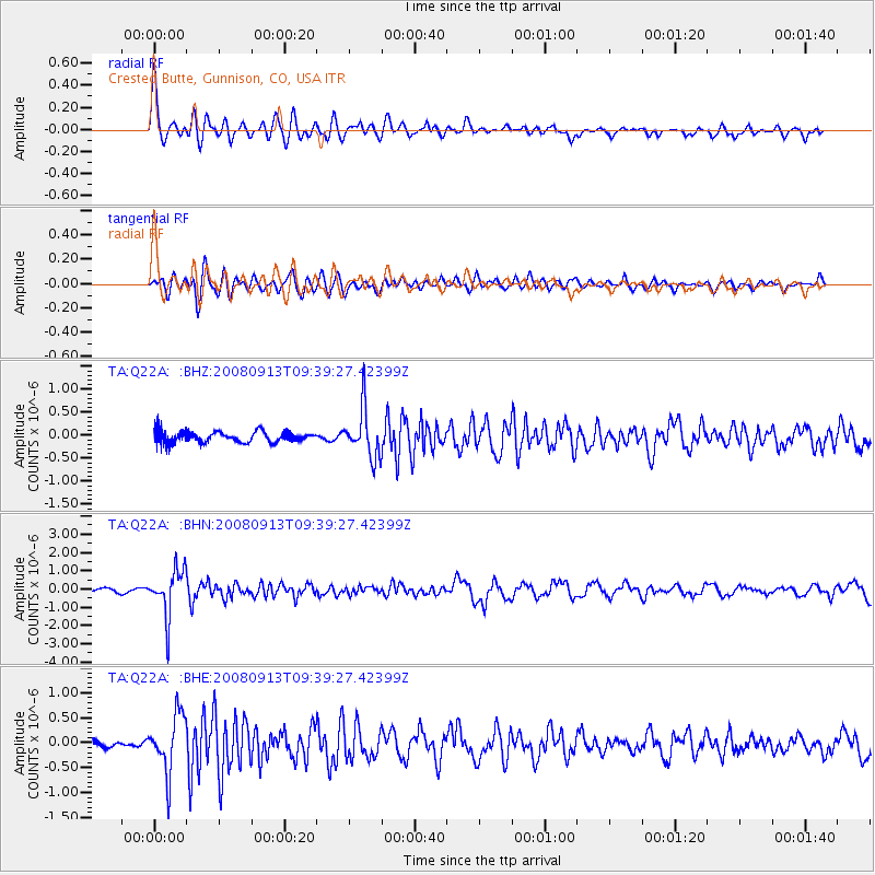
Q22A Crested Butte, Gunnison, CO, USA - Earthquake Result Viewer
*The percent match for this event was below the threshold and hence no stack was calculated.
| Earthquake location: |
Colombia |
| Earthquake latitude/longitude: |
4.8/-75.5 |
| Earthquake time(UTC): |
2008/09/13 (257) 09:32:01 GMT |
| Earthquake Depth: |
133 km |
| Earthquake Magnitude: |
5.9 MB, 5.7 MW, 5.7 MW |
| Earthquake Catalog/Contributor: |
WHDF/NEIC |
|
| Network: |
TA USArray Transportable Network (new EarthScope stations) |
| Station: |
Q22A Crested Butte, Gunnison, CO, USA |
| Lat/Lon: |
38.86 N/106.91 W |
| Elevation: |
2727 m |
|
| Distance: |
44.3 deg |
| Az: |
324.373 deg |
| Baz: |
131.965 deg |
| Ray Param: |
$rayparam |
*The percent match for this event was below the threshold and hence was not used in the summary stack. |
|
| Radial Match: |
75.184746 % |
| Radial Bump: |
400 |
| Transverse Match: |
58.20505 % |
| Transverse Bump: |
400 |
| SOD ConfigId: |
2560 |
| Insert Time: |
2010-03-06 07:26:25.538 +0000 |
| GWidth: |
2.5 |
| Max Bumps: |
400 |
| Tol: |
0.001 |
|
Signal To Noise
| Channel | StoN | STA | LTA |
| TA:Q22A: :BHN:20080913T09:39:27.42399Z | 11.988413 | 1.2725037E-6 | 1.06144476E-7 |
| TA:Q22A: :BHE:20080913T09:39:27.42399Z | 6.478955 | 5.824555E-7 | 8.9899615E-8 |
| TA:Q22A: :BHZ:20080913T09:39:27.42399Z | 4.549615 | 5.309752E-7 | 1.1670773E-7 |
| Arrivals |
| Ps | |
| PpPs | |
| PsPs/PpSs | |


