You are here: Home > Network List > TA - USArray Transportable Network (new EarthScope stations) Stations List
> Station Q22A Crested Butte, Gunnison, CO, USA > Earthquake Result Viewer
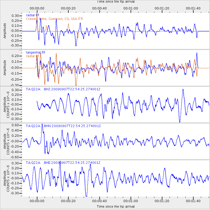
Q22A Crested Butte, Gunnison, CO, USA - Earthquake Result Viewer
*The percent match for this event was below the threshold and hence no stack was calculated.
| Earthquake location: |
Northwestern Caucasus |
| Earthquake latitude/longitude: |
42.7/43.4 |
| Earthquake time(UTC): |
2009/09/07 (250) 22:41:37 GMT |
| Earthquake Depth: |
15 km |
| Earthquake Magnitude: |
5.7 MB, 5.8 MS, 6.0 MW, 5.9 MW |
| Earthquake Catalog/Contributor: |
WHDF/NEIC |
|
| Network: |
TA USArray Transportable Network (new EarthScope stations) |
| Station: |
Q22A Crested Butte, Gunnison, CO, USA |
| Lat/Lon: |
38.86 N/106.91 W |
| Elevation: |
2727 m |
|
| Distance: |
94.5 deg |
| Az: |
337.208 deg |
| Baz: |
21.47 deg |
| Ray Param: |
$rayparam |
*The percent match for this event was below the threshold and hence was not used in the summary stack. |
|
| Radial Match: |
56.08285 % |
| Radial Bump: |
400 |
| Transverse Match: |
46.7917 % |
| Transverse Bump: |
400 |
| SOD ConfigId: |
2622 |
| Insert Time: |
2010-03-06 07:26:37.324 +0000 |
| GWidth: |
2.5 |
| Max Bumps: |
400 |
| Tol: |
0.001 |
|
Signal To Noise
| Channel | StoN | STA | LTA |
| TA:Q22A: :BHN:20090907T22:54:25.274001Z | 3.6468012 | 2.693551E-7 | 7.386065E-8 |
| TA:Q22A: :BHE:20090907T22:54:25.274001Z | 1.6896425 | 1.6420387E-7 | 9.718261E-8 |
| TA:Q22A: :BHZ:20090907T22:54:25.274001Z | 1.4891969 | 1.3752576E-7 | 9.234894E-8 |
| Arrivals |
| Ps | |
| PpPs | |
| PsPs/PpSs | |


