You are here: Home > Network List > AU - Australian Seismological Centre Stations List
> Station PSAB2 Pilbara Seismic Array Element B2 > Earthquake Result Viewer
PSAB2 Pilbara Seismic Array Element B2 - Earthquake Result Viewer
| Earthquake location: |
Vanuatu Islands |
| Earthquake latitude/longitude: |
-14.5/166.4 |
| Earthquake time(UTC): |
2016/04/14 (105) 21:50:26 GMT |
| Earthquake Depth: |
10 km |
| Earthquake Magnitude: |
6.5 MWP, 6.2 MWB, 6.6 MI |
| Earthquake Catalog/Contributor: |
NEIC PDE/NEIC COMCAT |
|
| Network: |
AU Australian Seismological Centre |
| Station: |
PSAB2 Pilbara Seismic Array Element B2 |
| Lat/Lon: |
21.55 S/119.86 E |
| Elevation: |
302 m |
|
| Distance: |
44.7 deg |
| Az: |
253.992 deg |
| Baz: |
89.112 deg |
| Ray Param: |
0.07177422 |
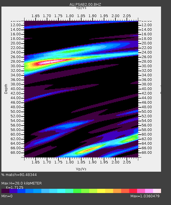
| Estimated Moho Depth: |
28.0 km |
| Estimated Crust Vp/Vs: |
1.71 |
| Assumed Crust Vp: |
6.464 km/s |
| Estimated Crust Vs: |
3.774 km/s |
| Estimated Crust Poisson's Ratio: |
0.24 |
|
| Radial Match: |
90.48344 % |
| Radial Bump: |
289 |
| Transverse Match: |
66.01269 % |
| Transverse Bump: |
400 |
| SOD ConfigId: |
1475611 |
| Insert Time: |
2016-04-28 21:50:52.318 +0000 |
| GWidth: |
2.5 |
| Max Bumps: |
400 |
| Tol: |
0.001 |
|

Signal To Noise
| Channel | StoN | STA | LTA |
| AU:PSAB2:00:BHZ:20160414T21:58:08.719006Z | 8.602895 | 1.4893884E-6 | 1.7312642E-7 |
| AU:PSAB2:00:BH1:20160414T21:58:08.719006Z | 4.750815 | 6.003019E-7 | 1.2635768E-7 |
| AU:PSAB2:00:BH2:20160414T21:58:08.719006Z | 4.8701205 | 6.1842E-7 | 1.2698248E-7 |
| Arrivals |
| Ps | 3.3 SECOND |
| PpPs | 11 SECOND |
| PsPs/PpSs | 14 SECOND |


