You are here: Home > Network List > TA - USArray Transportable Network (new EarthScope stations) Stations List
> Station Q22A Crested Butte, Gunnison, CO, USA > Earthquake Result Viewer
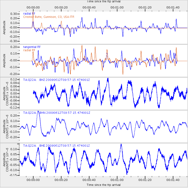
Q22A Crested Butte, Gunnison, CO, USA - Earthquake Result Viewer
*The percent match for this event was below the threshold and hence no stack was calculated.
| Earthquake location: |
Vanuatu Islands |
| Earthquake latitude/longitude: |
-17.6/167.8 |
| Earthquake time(UTC): |
2009/06/12 (163) 09:44:15 GMT |
| Earthquake Depth: |
15 km |
| Earthquake Magnitude: |
5.5 MB, 5.6 MS, 6.0 MW, 6.0 MW |
| Earthquake Catalog/Contributor: |
WHDF/NEIC |
|
| Network: |
TA USArray Transportable Network (new EarthScope stations) |
| Station: |
Q22A Crested Butte, Gunnison, CO, USA |
| Lat/Lon: |
38.86 N/106.91 W |
| Elevation: |
2727 m |
|
| Distance: |
97.3 deg |
| Az: |
51.662 deg |
| Baz: |
253.374 deg |
| Ray Param: |
$rayparam |
*The percent match for this event was below the threshold and hence was not used in the summary stack. |
|
| Radial Match: |
62.350544 % |
| Radial Bump: |
400 |
| Transverse Match: |
73.45995 % |
| Transverse Bump: |
393 |
| SOD ConfigId: |
2648 |
| Insert Time: |
2010-03-06 07:27:06.734 +0000 |
| GWidth: |
2.5 |
| Max Bumps: |
400 |
| Tol: |
0.001 |
|
Signal To Noise
| Channel | StoN | STA | LTA |
| TA:Q22A: :BHN:20090612T09:57:15.474001Z | 2.3410432 | 1.5208518E-7 | 6.49647E-8 |
| TA:Q22A: :BHE:20090612T09:57:15.474001Z | 2.195288 | 5.975324E-8 | 2.7218864E-8 |
| TA:Q22A: :BHZ:20090612T09:57:15.474001Z | 1.1940686 | 4.469186E-8 | 3.742822E-8 |
| Arrivals |
| Ps | |
| PpPs | |
| PsPs/PpSs | |


