You are here: Home > Network List > TA - USArray Transportable Network (new EarthScope stations) Stations List
> Station B18K Kokolik River, AK, USA > Earthquake Result Viewer
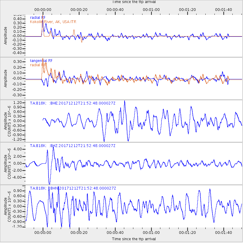
B18K Kokolik River, AK, USA - Earthquake Result Viewer
*The percent match for this event was below the threshold and hence no stack was calculated.
| Earthquake location: |
Northern And Central Iran |
| Earthquake latitude/longitude: |
30.8/57.3 |
| Earthquake time(UTC): |
2017/12/12 (346) 21:41:31 GMT |
| Earthquake Depth: |
8.0 km |
| Earthquake Magnitude: |
6.0 Mww |
| Earthquake Catalog/Contributor: |
NEIC PDE/us |
|
| Network: |
TA USArray Transportable Network (new EarthScope stations) |
| Station: |
B18K Kokolik River, AK, USA |
| Lat/Lon: |
69.36 N/161.80 W |
| Elevation: |
222 m |
|
| Distance: |
76.1 deg |
| Az: |
13.312 deg |
| Baz: |
326.031 deg |
| Ray Param: |
$rayparam |
*The percent match for this event was below the threshold and hence was not used in the summary stack. |
|
| Radial Match: |
66.77774 % |
| Radial Bump: |
400 |
| Transverse Match: |
65.00182 % |
| Transverse Bump: |
400 |
| SOD ConfigId: |
13570011 |
| Insert Time: |
2019-04-29 10:29:06.039 +0000 |
| GWidth: |
2.5 |
| Max Bumps: |
400 |
| Tol: |
0.001 |
|
Signal To Noise
| Channel | StoN | STA | LTA |
| TA:B18K: :BHZ:20171212T21:52:48.000027Z | 5.549536 | 2.6370635E-6 | 4.7518628E-7 |
| TA:B18K: :BHN:20171212T21:52:48.000027Z | 1.5577866 | 5.37918E-7 | 3.4530922E-7 |
| TA:B18K: :BHE:20171212T21:52:48.000027Z | 2.8516793 | 6.6442453E-7 | 2.3299414E-7 |
| Arrivals |
| Ps | |
| PpPs | |
| PsPs/PpSs | |


