You are here: Home > Network List > TA - USArray Transportable Network (new EarthScope stations) Stations List
> Station C17K DeLong Mountains, AK, USA > Earthquake Result Viewer
C17K DeLong Mountains, AK, USA - Earthquake Result Viewer
| Earthquake location: |
Northern And Central Iran |
| Earthquake latitude/longitude: |
30.8/57.3 |
| Earthquake time(UTC): |
2017/12/12 (346) 21:41:31 GMT |
| Earthquake Depth: |
8.0 km |
| Earthquake Magnitude: |
6.0 Mww |
| Earthquake Catalog/Contributor: |
NEIC PDE/us |
|
| Network: |
TA USArray Transportable Network (new EarthScope stations) |
| Station: |
C17K DeLong Mountains, AK, USA |
| Lat/Lon: |
68.48 N/163.18 W |
| Elevation: |
498 m |
|
| Distance: |
76.6 deg |
| Az: |
14.255 deg |
| Baz: |
324.971 deg |
| Ray Param: |
0.05091178 |
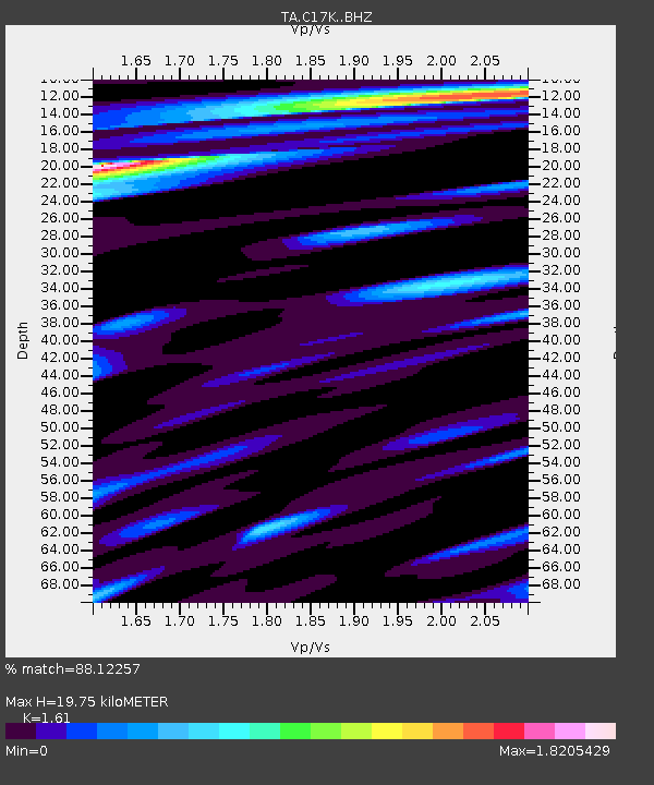
| Estimated Moho Depth: |
19.75 km |
| Estimated Crust Vp/Vs: |
1.61 |
| Assumed Crust Vp: |
5.906 km/s |
| Estimated Crust Vs: |
3.669 km/s |
| Estimated Crust Poisson's Ratio: |
0.19 |
|
| Radial Match: |
88.12257 % |
| Radial Bump: |
400 |
| Transverse Match: |
80.92214 % |
| Transverse Bump: |
400 |
| SOD ConfigId: |
13570011 |
| Insert Time: |
2019-04-29 10:29:12.533 +0000 |
| GWidth: |
2.5 |
| Max Bumps: |
400 |
| Tol: |
0.001 |
|

Signal To Noise
| Channel | StoN | STA | LTA |
| TA:C17K: :BHZ:20171212T21:52:50.574978Z | 11.174081 | 2.6559846E-6 | 2.3769155E-7 |
| TA:C17K: :BHN:20171212T21:52:50.574978Z | 3.6992779 | 8.621087E-7 | 2.3304784E-7 |
| TA:C17K: :BHE:20171212T21:52:50.574978Z | 1.1108388 | 3.1700304E-7 | 2.853727E-7 |
| Arrivals |
| Ps | 2.1 SECOND |
| PpPs | 8.5 SECOND |
| PsPs/PpSs | 11 SECOND |


