You are here: Home > Network List > TA - USArray Transportable Network (new EarthScope stations) Stations List
> Station C21K Knifeblade Ridge, AK, USA > Earthquake Result Viewer
C21K Knifeblade Ridge, AK, USA - Earthquake Result Viewer
| Earthquake location: |
Northern And Central Iran |
| Earthquake latitude/longitude: |
30.8/57.3 |
| Earthquake time(UTC): |
2017/12/12 (346) 21:41:31 GMT |
| Earthquake Depth: |
8.0 km |
| Earthquake Magnitude: |
6.0 Mww |
| Earthquake Catalog/Contributor: |
NEIC PDE/us |
|
| Network: |
TA USArray Transportable Network (new EarthScope stations) |
| Station: |
C21K Knifeblade Ridge, AK, USA |
| Lat/Lon: |
69.16 N/154.78 W |
| Elevation: |
409 m |
|
| Distance: |
77.6 deg |
| Az: |
11.221 deg |
| Baz: |
332.114 deg |
| Ray Param: |
0.050232973 |
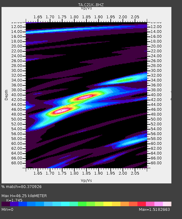
| Estimated Moho Depth: |
46.25 km |
| Estimated Crust Vp/Vs: |
1.75 |
| Assumed Crust Vp: |
6.221 km/s |
| Estimated Crust Vs: |
3.565 km/s |
| Estimated Crust Poisson's Ratio: |
0.26 |
|
| Radial Match: |
80.370926 % |
| Radial Bump: |
400 |
| Transverse Match: |
60.840435 % |
| Transverse Bump: |
400 |
| SOD ConfigId: |
13570011 |
| Insert Time: |
2019-04-29 10:29:13.321 +0000 |
| GWidth: |
2.5 |
| Max Bumps: |
400 |
| Tol: |
0.001 |
|

Signal To Noise
| Channel | StoN | STA | LTA |
| TA:C21K: :BHZ:20171212T21:52:56.225002Z | 8.362091 | 2.4815124E-6 | 2.9675738E-7 |
| TA:C21K: :BHN:20171212T21:52:56.225002Z | 1.3325255 | 4.9388115E-7 | 3.706354E-7 |
| TA:C21K: :BHE:20171212T21:52:56.225002Z | 0.5977337 | 1.6538512E-7 | 2.7668696E-7 |
| Arrivals |
| Ps | 5.7 SECOND |
| PpPs | 20 SECOND |
| PsPs/PpSs | 26 SECOND |


