You are here: Home > Network List > TA - USArray Transportable Network (new EarthScope stations) Stations List
> Station D23K Nanushuk River, AK USA > Earthquake Result Viewer
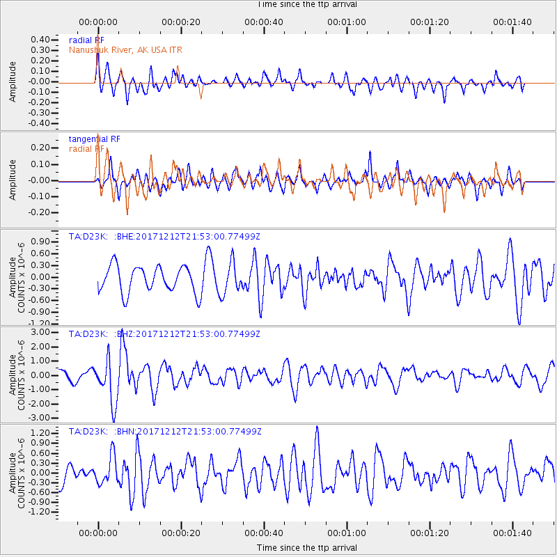
D23K Nanushuk River, AK USA - Earthquake Result Viewer
*The percent match for this event was below the threshold and hence no stack was calculated.
| Earthquake location: |
Northern And Central Iran |
| Earthquake latitude/longitude: |
30.8/57.3 |
| Earthquake time(UTC): |
2017/12/12 (346) 21:41:31 GMT |
| Earthquake Depth: |
8.0 km |
| Earthquake Magnitude: |
6.0 Mww |
| Earthquake Catalog/Contributor: |
NEIC PDE/us |
|
| Network: |
TA USArray Transportable Network (new EarthScope stations) |
| Station: |
D23K Nanushuk River, AK USA |
| Lat/Lon: |
68.97 N/150.68 W |
| Elevation: |
406 m |
|
| Distance: |
78.4 deg |
| Az: |
9.953 deg |
| Baz: |
335.679 deg |
| Ray Param: |
$rayparam |
*The percent match for this event was below the threshold and hence was not used in the summary stack. |
|
| Radial Match: |
69.76675 % |
| Radial Bump: |
400 |
| Transverse Match: |
51.037823 % |
| Transverse Bump: |
400 |
| SOD ConfigId: |
13570011 |
| Insert Time: |
2019-04-29 10:29:21.132 +0000 |
| GWidth: |
2.5 |
| Max Bumps: |
400 |
| Tol: |
0.001 |
|
Signal To Noise
| Channel | StoN | STA | LTA |
| TA:D23K: :BHZ:20171212T21:53:00.77499Z | 4.4284897 | 1.5479962E-6 | 3.49554E-7 |
| TA:D23K: :BHN:20171212T21:53:00.77499Z | 1.7242591 | 4.3916035E-7 | 2.546951E-7 |
| TA:D23K: :BHE:20171212T21:53:00.77499Z | 1.1905192 | 4.0056477E-7 | 3.3646222E-7 |
| Arrivals |
| Ps | |
| PpPs | |
| PsPs/PpSs | |


