You are here: Home > Network List > TA - USArray Transportable Network (new EarthScope stations) Stations List
> Station D25K Kavik River, AK, USA > Earthquake Result Viewer
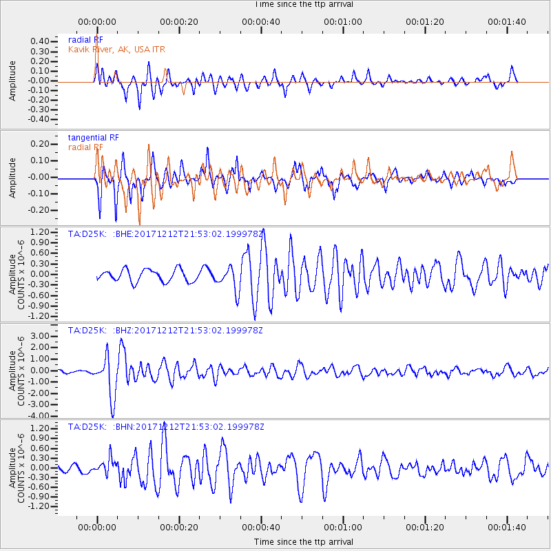
D25K Kavik River, AK, USA - Earthquake Result Viewer
*The percent match for this event was below the threshold and hence no stack was calculated.
| Earthquake location: |
Northern And Central Iran |
| Earthquake latitude/longitude: |
30.8/57.3 |
| Earthquake time(UTC): |
2017/12/12 (346) 21:41:31 GMT |
| Earthquake Depth: |
8.0 km |
| Earthquake Magnitude: |
6.0 Mww |
| Earthquake Catalog/Contributor: |
NEIC PDE/us |
|
| Network: |
TA USArray Transportable Network (new EarthScope stations) |
| Station: |
D25K Kavik River, AK, USA |
| Lat/Lon: |
69.32 N/146.38 W |
| Elevation: |
770 m |
|
| Distance: |
78.7 deg |
| Az: |
8.36 deg |
| Baz: |
339.382 deg |
| Ray Param: |
$rayparam |
*The percent match for this event was below the threshold and hence was not used in the summary stack. |
|
| Radial Match: |
75.841484 % |
| Radial Bump: |
400 |
| Transverse Match: |
86.798386 % |
| Transverse Bump: |
344 |
| SOD ConfigId: |
13570011 |
| Insert Time: |
2019-04-29 10:29:21.252 +0000 |
| GWidth: |
2.5 |
| Max Bumps: |
400 |
| Tol: |
0.001 |
|
Signal To Noise
| Channel | StoN | STA | LTA |
| TA:D25K: :BHZ:20171212T21:53:02.199978Z | 10.99935 | 1.8149383E-6 | 1.6500414E-7 |
| TA:D25K: :BHN:20171212T21:53:02.199978Z | 1.4609264 | 2.4299513E-7 | 1.6632949E-7 |
| TA:D25K: :BHE:20171212T21:53:02.199978Z | 2.1098146 | 3.5714456E-7 | 1.6927768E-7 |
| Arrivals |
| Ps | |
| PpPs | |
| PsPs/PpSs | |


