You are here: Home > Network List > TA - USArray Transportable Network (new EarthScope stations) Stations List
> Station E18K Tukpahlearik Creek, AK, USA > Earthquake Result Viewer
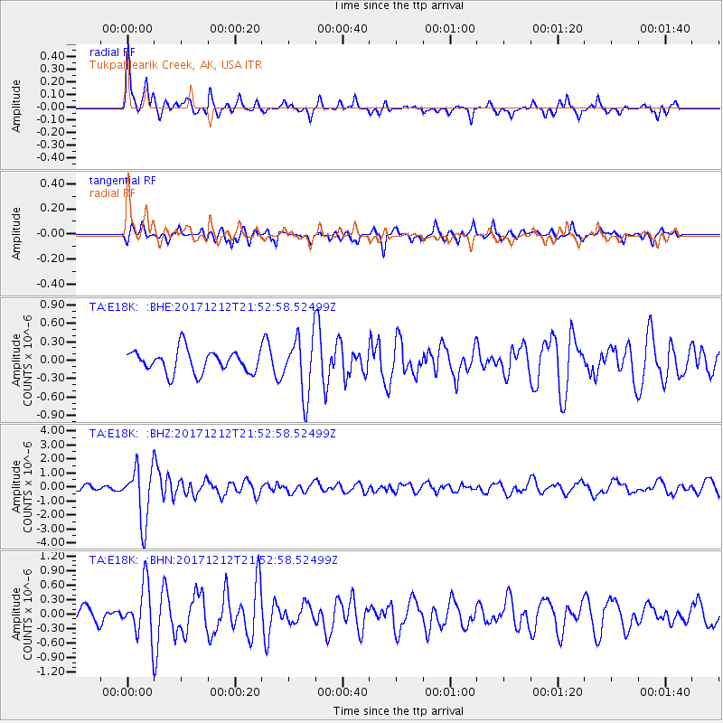
E18K Tukpahlearik Creek, AK, USA - Earthquake Result Viewer
*The percent match for this event was below the threshold and hence no stack was calculated.
| Earthquake location: |
Northern And Central Iran |
| Earthquake latitude/longitude: |
30.8/57.3 |
| Earthquake time(UTC): |
2017/12/12 (346) 21:41:31 GMT |
| Earthquake Depth: |
8.0 km |
| Earthquake Magnitude: |
6.0 Mww |
| Earthquake Catalog/Contributor: |
NEIC PDE/us |
|
| Network: |
TA USArray Transportable Network (new EarthScope stations) |
| Station: |
E18K Tukpahlearik Creek, AK, USA |
| Lat/Lon: |
67.42 N/160.60 W |
| Elevation: |
297 m |
|
| Distance: |
78.0 deg |
| Az: |
14.032 deg |
| Baz: |
327.307 deg |
| Ray Param: |
$rayparam |
*The percent match for this event was below the threshold and hence was not used in the summary stack. |
|
| Radial Match: |
73.86318 % |
| Radial Bump: |
339 |
| Transverse Match: |
69.674355 % |
| Transverse Bump: |
390 |
| SOD ConfigId: |
13570011 |
| Insert Time: |
2019-04-29 10:29:25.506 +0000 |
| GWidth: |
2.5 |
| Max Bumps: |
400 |
| Tol: |
0.001 |
|
Signal To Noise
| Channel | StoN | STA | LTA |
| TA:E18K: :BHZ:20171212T21:52:58.52499Z | 9.39878 | 1.9646338E-6 | 2.0903072E-7 |
| TA:E18K: :BHN:20171212T21:52:58.52499Z | 2.0846324 | 5.3598933E-7 | 2.5711455E-7 |
| TA:E18K: :BHE:20171212T21:52:58.52499Z | 2.643057 | 4.7872373E-7 | 1.81125E-7 |
| Arrivals |
| Ps | |
| PpPs | |
| PsPs/PpSs | |


