You are here: Home > Network List > TA - USArray Transportable Network (new EarthScope stations) Stations List
> Station F20K Avaraart Lake, AK, USA > Earthquake Result Viewer
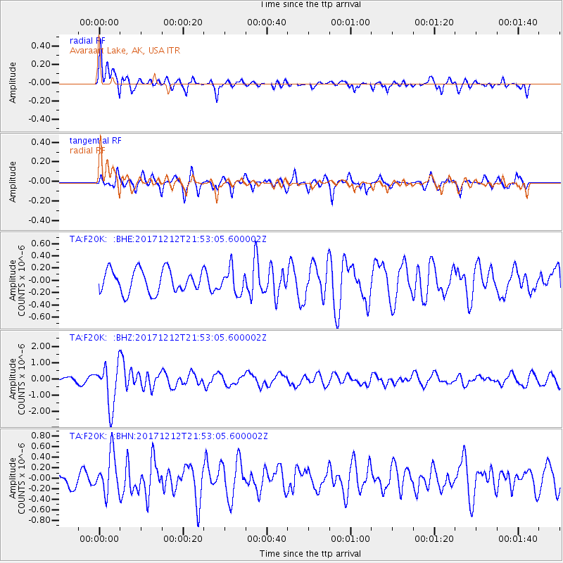
F20K Avaraart Lake, AK, USA - Earthquake Result Viewer
*The percent match for this event was below the threshold and hence no stack was calculated.
| Earthquake location: |
Northern And Central Iran |
| Earthquake latitude/longitude: |
30.8/57.3 |
| Earthquake time(UTC): |
2017/12/12 (346) 21:41:31 GMT |
| Earthquake Depth: |
8.0 km |
| Earthquake Magnitude: |
6.0 Mww |
| Earthquake Catalog/Contributor: |
NEIC PDE/us |
|
| Network: |
TA USArray Transportable Network (new EarthScope stations) |
| Station: |
F20K Avaraart Lake, AK, USA |
| Lat/Lon: |
67.05 N/155.73 W |
| Elevation: |
136 m |
|
| Distance: |
79.3 deg |
| Az: |
12.56 deg |
| Baz: |
331.51 deg |
| Ray Param: |
$rayparam |
*The percent match for this event was below the threshold and hence was not used in the summary stack. |
|
| Radial Match: |
71.85125 % |
| Radial Bump: |
400 |
| Transverse Match: |
72.53766 % |
| Transverse Bump: |
344 |
| SOD ConfigId: |
13570011 |
| Insert Time: |
2019-04-29 10:29:35.676 +0000 |
| GWidth: |
2.5 |
| Max Bumps: |
400 |
| Tol: |
0.001 |
|
Signal To Noise
| Channel | StoN | STA | LTA |
| TA:F20K: :BHZ:20171212T21:53:05.600002Z | 8.870236 | 1.3464526E-6 | 1.5179444E-7 |
| TA:F20K: :BHN:20171212T21:53:05.600002Z | 2.878938 | 3.8204402E-7 | 1.3270311E-7 |
| TA:F20K: :BHE:20171212T21:53:05.600002Z | 1.102391 | 2.0411738E-7 | 1.851588E-7 |
| Arrivals |
| Ps | |
| PpPs | |
| PsPs/PpSs | |


