You are here: Home > Network List > TA - USArray Transportable Network (new EarthScope stations) Stations List
> Station F26K Sheenjek River, AK, USA > Earthquake Result Viewer
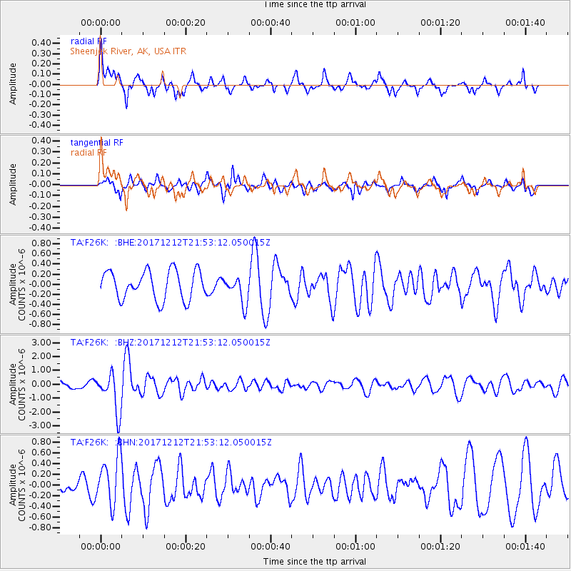
F26K Sheenjek River, AK, USA - Earthquake Result Viewer
*The percent match for this event was below the threshold and hence no stack was calculated.
| Earthquake location: |
Northern And Central Iran |
| Earthquake latitude/longitude: |
30.8/57.3 |
| Earthquake time(UTC): |
2017/12/12 (346) 21:41:31 GMT |
| Earthquake Depth: |
8.0 km |
| Earthquake Magnitude: |
6.0 Mww |
| Earthquake Catalog/Contributor: |
NEIC PDE/us |
|
| Network: |
TA USArray Transportable Network (new EarthScope stations) |
| Station: |
F26K Sheenjek River, AK, USA |
| Lat/Lon: |
67.69 N/144.15 W |
| Elevation: |
683 m |
|
| Distance: |
80.5 deg |
| Az: |
8.131 deg |
| Baz: |
341.414 deg |
| Ray Param: |
$rayparam |
*The percent match for this event was below the threshold and hence was not used in the summary stack. |
|
| Radial Match: |
75.74447 % |
| Radial Bump: |
400 |
| Transverse Match: |
63.82822 % |
| Transverse Bump: |
393 |
| SOD ConfigId: |
13570011 |
| Insert Time: |
2019-04-29 10:29:39.110 +0000 |
| GWidth: |
2.5 |
| Max Bumps: |
400 |
| Tol: |
0.001 |
|
Signal To Noise
| Channel | StoN | STA | LTA |
| TA:F26K: :BHZ:20171212T21:53:12.050015Z | 4.987471 | 1.4660465E-6 | 2.9394587E-7 |
| TA:F26K: :BHN:20171212T21:53:12.050015Z | 4.270411 | 4.7162914E-7 | 1.10441164E-7 |
| TA:F26K: :BHE:20171212T21:53:12.050015Z | 0.9739544 | 2.756261E-7 | 2.8299692E-7 |
| Arrivals |
| Ps | |
| PpPs | |
| PsPs/PpSs | |


