You are here: Home > Network List > TA - USArray Transportable Network (new EarthScope stations) Stations List
> Station H22K Ishtalitna Creek, AK, USA > Earthquake Result Viewer
H22K Ishtalitna Creek, AK, USA - Earthquake Result Viewer
| Earthquake location: |
Northern And Central Iran |
| Earthquake latitude/longitude: |
30.8/57.3 |
| Earthquake time(UTC): |
2017/12/12 (346) 21:41:31 GMT |
| Earthquake Depth: |
8.0 km |
| Earthquake Magnitude: |
6.0 Mww |
| Earthquake Catalog/Contributor: |
NEIC PDE/us |
|
| Network: |
TA USArray Transportable Network (new EarthScope stations) |
| Station: |
H22K Ishtalitna Creek, AK, USA |
| Lat/Lon: |
65.89 N/151.38 W |
| Elevation: |
561 m |
|
| Distance: |
81.1 deg |
| Az: |
11.503 deg |
| Baz: |
335.312 deg |
| Ray Param: |
0.04783261 |
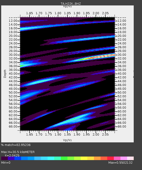
| Estimated Moho Depth: |
30.5 km |
| Estimated Crust Vp/Vs: |
2.04 |
| Assumed Crust Vp: |
6.566 km/s |
| Estimated Crust Vs: |
3.215 km/s |
| Estimated Crust Poisson's Ratio: |
0.34 |
|
| Radial Match: |
82.95236 % |
| Radial Bump: |
309 |
| Transverse Match: |
64.44411 % |
| Transverse Bump: |
400 |
| SOD ConfigId: |
13570011 |
| Insert Time: |
2019-04-29 10:29:58.293 +0000 |
| GWidth: |
2.5 |
| Max Bumps: |
400 |
| Tol: |
0.001 |
|

Signal To Noise
| Channel | StoN | STA | LTA |
| TA:H22K: :BHZ:20171212T21:53:15.350002Z | 8.965574 | 2.0432544E-6 | 2.2789999E-7 |
| TA:H22K: :BHN:20171212T21:53:15.350002Z | 2.4227016 | 6.5140097E-7 | 2.688738E-7 |
| TA:H22K: :BHE:20171212T21:53:15.350002Z | 2.953914 | 4.9963137E-7 | 1.6914217E-7 |
| Arrivals |
| Ps | 5.0 SECOND |
| PpPs | 14 SECOND |
| PsPs/PpSs | 19 SECOND |


