You are here: Home > Network List > TA - USArray Transportable Network (new EarthScope stations) Stations List
> Station H31M Peel River, Yukon, CAN > Earthquake Result Viewer
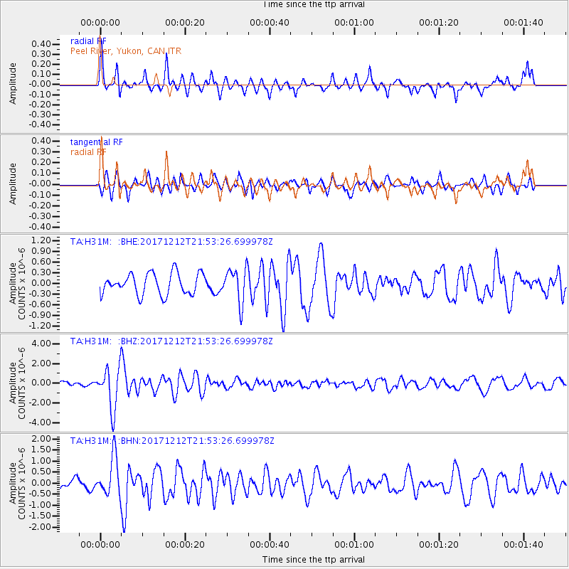
H31M Peel River, Yukon, CAN - Earthquake Result Viewer
*The percent match for this event was below the threshold and hence no stack was calculated.
| Earthquake location: |
Northern And Central Iran |
| Earthquake latitude/longitude: |
30.8/57.3 |
| Earthquake time(UTC): |
2017/12/12 (346) 21:41:31 GMT |
| Earthquake Depth: |
8.0 km |
| Earthquake Magnitude: |
6.0 Mww |
| Earthquake Catalog/Contributor: |
NEIC PDE/us |
|
| Network: |
TA USArray Transportable Network (new EarthScope stations) |
| Station: |
H31M Peel River, Yukon, CAN |
| Lat/Lon: |
65.81 N/134.34 W |
| Elevation: |
642 m |
|
| Distance: |
83.3 deg |
| Az: |
4.798 deg |
| Baz: |
349.944 deg |
| Ray Param: |
$rayparam |
*The percent match for this event was below the threshold and hence was not used in the summary stack. |
|
| Radial Match: |
76.03542 % |
| Radial Bump: |
376 |
| Transverse Match: |
54.139942 % |
| Transverse Bump: |
349 |
| SOD ConfigId: |
13570011 |
| Insert Time: |
2019-04-29 10:30:00.972 +0000 |
| GWidth: |
2.5 |
| Max Bumps: |
400 |
| Tol: |
0.001 |
|
Signal To Noise
| Channel | StoN | STA | LTA |
| TA:H31M: :BHZ:20171212T21:53:26.699978Z | 4.5497503 | 2.1539392E-6 | 4.7341922E-7 |
| TA:H31M: :BHN:20171212T21:53:26.699978Z | 2.287503 | 9.032601E-7 | 3.948673E-7 |
| TA:H31M: :BHE:20171212T21:53:26.699978Z | 1.6875331 | 4.996746E-7 | 2.9609768E-7 |
| Arrivals |
| Ps | |
| PpPs | |
| PsPs/PpSs | |


