You are here: Home > Network List > TA - USArray Transportable Network (new EarthScope stations) Stations List
> Station M31M Drury Creek, Yukon, CA > Earthquake Result Viewer
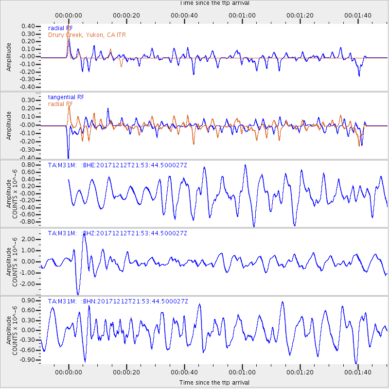
M31M Drury Creek, Yukon, CA - Earthquake Result Viewer
*The percent match for this event was below the threshold and hence no stack was calculated.
| Earthquake location: |
Northern And Central Iran |
| Earthquake latitude/longitude: |
30.8/57.3 |
| Earthquake time(UTC): |
2017/12/12 (346) 21:41:31 GMT |
| Earthquake Depth: |
8.0 km |
| Earthquake Magnitude: |
6.0 Mww |
| Earthquake Catalog/Contributor: |
NEIC PDE/us |
|
| Network: |
TA USArray Transportable Network (new EarthScope stations) |
| Station: |
M31M Drury Creek, Yukon, CA |
| Lat/Lon: |
62.20 N/134.39 W |
| Elevation: |
639 m |
|
| Distance: |
86.8 deg |
| Az: |
5.453 deg |
| Baz: |
349.958 deg |
| Ray Param: |
$rayparam |
*The percent match for this event was below the threshold and hence was not used in the summary stack. |
|
| Radial Match: |
47.745678 % |
| Radial Bump: |
400 |
| Transverse Match: |
49.046753 % |
| Transverse Bump: |
400 |
| SOD ConfigId: |
13570011 |
| Insert Time: |
2019-04-29 10:30:39.138 +0000 |
| GWidth: |
2.5 |
| Max Bumps: |
400 |
| Tol: |
0.001 |
|
Signal To Noise
| Channel | StoN | STA | LTA |
| TA:M31M: :BHZ:20171212T21:53:44.500027Z | 4.260339 | 1.370592E-6 | 3.2170962E-7 |
| TA:M31M: :BHN:20171212T21:53:44.500027Z | 0.59734184 | 2.368451E-7 | 3.9649842E-7 |
| TA:M31M: :BHE:20171212T21:53:44.500027Z | 1.4537404 | 3.1999414E-7 | 2.201178E-7 |
| Arrivals |
| Ps | |
| PpPs | |
| PsPs/PpSs | |


