You are here: Home > Network List > TA - USArray Transportable Network (new EarthScope stations) Stations List
> Station Z24A Sheeppen Canyon, Tinnie, NM, USA > Earthquake Result Viewer
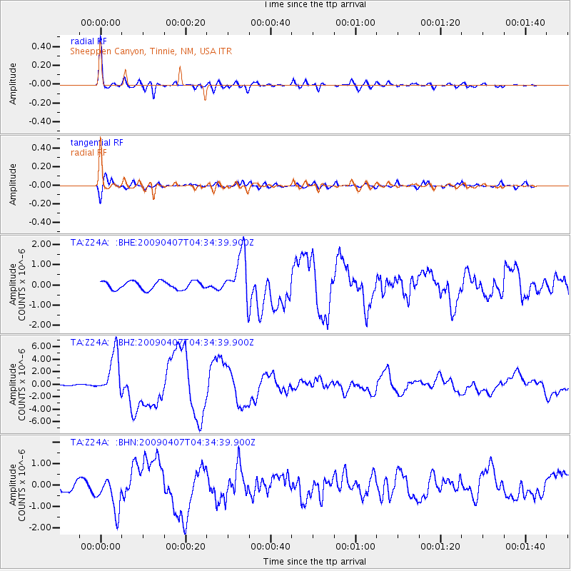
Z24A Sheeppen Canyon, Tinnie, NM, USA - Earthquake Result Viewer
| Earthquake location: |
Kuril Islands |
| Earthquake latitude/longitude: |
46.0/151.5 |
| Earthquake time(UTC): |
2009/04/07 (097) 04:23:33 GMT |
| Earthquake Depth: |
31 km |
| Earthquake Magnitude: |
6.5 MB, 6.8 MS, 6.9 MW, 6.9 MW |
| Earthquake Catalog/Contributor: |
WHDF/NEIC |
|
| Network: |
TA USArray Transportable Network (new EarthScope stations) |
| Station: |
Z24A Sheeppen Canyon, Tinnie, NM, USA |
| Lat/Lon: |
33.33 N/105.36 W |
| Elevation: |
1863 m |
|
| Distance: |
74.9 deg |
| Az: |
57.63 deg |
| Baz: |
315.363 deg |
| Ray Param: |
0.05197645 |
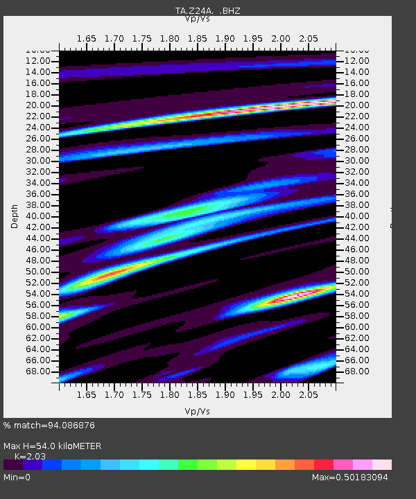
| Estimated Moho Depth: |
54.0 km |
| Estimated Crust Vp/Vs: |
2.03 |
| Assumed Crust Vp: |
6.232 km/s |
| Estimated Crust Vs: |
3.07 km/s |
| Estimated Crust Poisson's Ratio: |
0.34 |
|
| Radial Match: |
94.086876 % |
| Radial Bump: |
400 |
| Transverse Match: |
87.637726 % |
| Transverse Bump: |
400 |
| SOD ConfigId: |
2658 |
| Insert Time: |
2010-03-06 07:27:42.229 +0000 |
| GWidth: |
2.5 |
| Max Bumps: |
400 |
| Tol: |
0.001 |
|
Signal To Noise
| Channel | StoN | STA | LTA |
| TA:Z24A: :BHZ:20090407T04:34:39.900Z | 13.803195 | 3.4663688E-6 | 2.51128E-7 |
| TA:Z24A: :BHN:20090407T04:34:39.900Z | 5.1192365 | 8.2958036E-7 | 1.6205158E-7 |
| TA:Z24A: :BHE:20090407T04:34:39.900Z | 5.84155 | 1.1698496E-6 | 2.0026357E-7 |
| Arrivals |
| Ps | 9.2 SECOND |
| PpPs | 26 SECOND |
| PsPs/PpSs | 35 SECOND |


