You are here: Home > Network List > TA - USArray Transportable Network (new EarthScope stations) Stations List
> Station Z24A Sheeppen Canyon, Tinnie, NM, USA > Earthquake Result Viewer
Z24A Sheeppen Canyon, Tinnie, NM, USA - Earthquake Result Viewer
| Earthquake location: |
Kuril Islands |
| Earthquake latitude/longitude: |
46.0/151.4 |
| Earthquake time(UTC): |
2009/04/18 (108) 19:17:58 GMT |
| Earthquake Depth: |
35 km |
| Earthquake Magnitude: |
6.3 MB, 6.3 MS, 6.6 MW, 6.4 MW |
| Earthquake Catalog/Contributor: |
WHDF/NEIC |
|
| Network: |
TA USArray Transportable Network (new EarthScope stations) |
| Station: |
Z24A Sheeppen Canyon, Tinnie, NM, USA |
| Lat/Lon: |
33.33 N/105.36 W |
| Elevation: |
1863 m |
|
| Distance: |
75.0 deg |
| Az: |
57.547 deg |
| Baz: |
315.38 deg |
| Ray Param: |
0.051910307 |
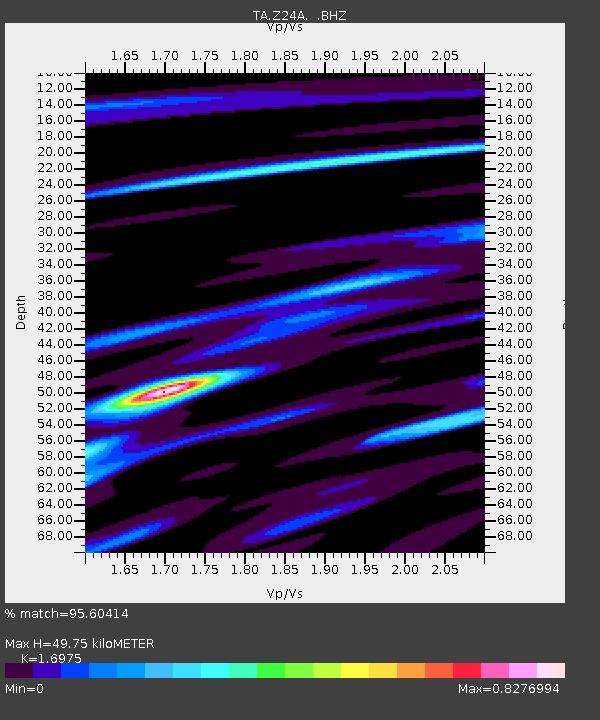
| Estimated Moho Depth: |
49.75 km |
| Estimated Crust Vp/Vs: |
1.70 |
| Assumed Crust Vp: |
6.232 km/s |
| Estimated Crust Vs: |
3.671 km/s |
| Estimated Crust Poisson's Ratio: |
0.23 |
|
| Radial Match: |
95.60414 % |
| Radial Bump: |
310 |
| Transverse Match: |
76.58833 % |
| Transverse Bump: |
400 |
| SOD ConfigId: |
2760 |
| Insert Time: |
2010-03-06 07:27:44.481 +0000 |
| GWidth: |
2.5 |
| Max Bumps: |
400 |
| Tol: |
0.001 |
|
Signal To Noise
| Channel | StoN | STA | LTA |
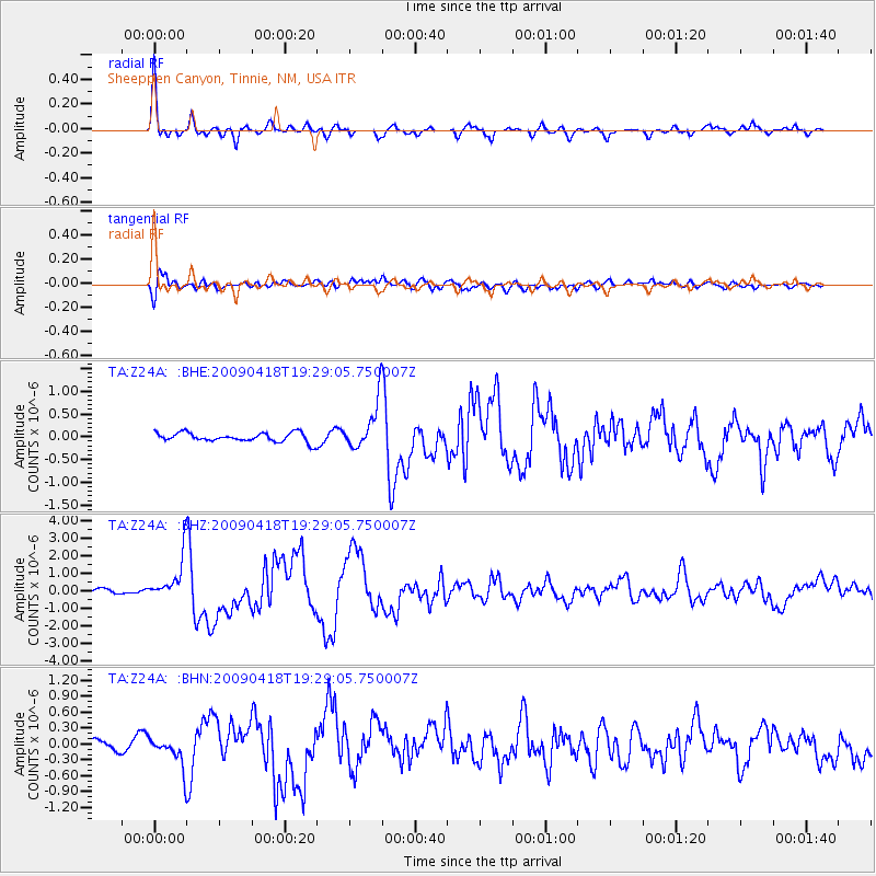
| TA:Z24A: :BHZ:20090418T19:29:05.750007Z | 7.080818 | 1.2258569E-6 | 1.7312361E-7 |
| TA:Z24A: :BHN:20090418T19:29:05.750007Z | 2.732531 | 2.7519454E-7 | 1.0071049E-7 |
| TA:Z24A: :BHE:20090418T19:29:05.750007Z | 5.302935 | 5.2440686E-7 | 9.888993E-8 |
| Arrivals |
| Ps | 5.7 SECOND |
| PpPs | 21 SECOND |
| PsPs/PpSs | 27 SECOND |


