You are here: Home > Network List > CN - Canadian National Seismograph Network Stations List
> Station INK INUVIK, NT > Earthquake Result Viewer
INK INUVIK, NT - Earthquake Result Viewer
*The percent match for this event was below the threshold and hence no stack was calculated.
| Earthquake location: |
Southeast Of Loyalty Islands |
| Earthquake latitude/longitude: |
-21.1/169.6 |
| Earthquake time(UTC): |
2017/12/14 (348) 20:36:36 GMT |
| Earthquake Depth: |
15 km |
| Earthquake Magnitude: |
5.5 Mww |
| Earthquake Catalog/Contributor: |
NEIC PDE/us |
|
| Network: |
CN Canadian National Seismograph Network |
| Station: |
INK INUVIK, NT |
| Lat/Lon: |
68.31 N/133.53 W |
| Elevation: |
44 m |
|
| Distance: |
98.2 deg |
| Az: |
18.347 deg |
| Baz: |
232.228 deg |
| Ray Param: |
$rayparam |
*The percent match for this event was below the threshold and hence was not used in the summary stack. |
|
| Radial Match: |
56.54533 % |
| Radial Bump: |
400 |
| Transverse Match: |
61.57767 % |
| Transverse Bump: |
400 |
| SOD ConfigId: |
13570011 |
| Insert Time: |
2019-04-29 10:36:23.044 +0000 |
| GWidth: |
2.5 |
| Max Bumps: |
400 |
| Tol: |
0.001 |
|
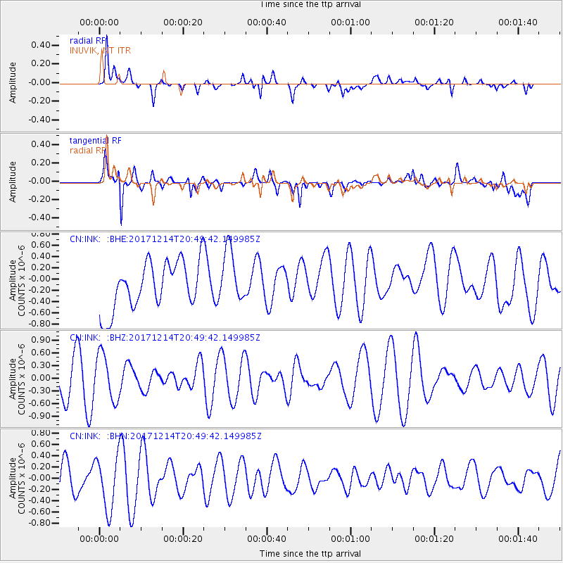
Signal To Noise
| Channel | StoN | STA | LTA |
| CN:INK: :BHZ:20171214T20:49:42.149985Z | 1.6253992 | 5.533226E-7 | 3.404226E-7 |
| CN:INK: :BHN:20171214T20:49:42.149985Z | 1.7357476 | 4.9214646E-7 | 2.8353574E-7 |
| CN:INK: :BHE:20171214T20:49:42.149985Z | 1.2279547 | 4.9878656E-7 | 4.0619292E-7 |
| Arrivals |
| Ps | |
| PpPs | |
| PsPs/PpSs | |


