You are here: Home > Network List > TA - USArray Transportable Network (new EarthScope stations) Stations List
> Station Z24A Sheeppen Canyon, Tinnie, NM, USA > Earthquake Result Viewer
Z24A Sheeppen Canyon, Tinnie, NM, USA - Earthquake Result Viewer

| Earthquake location: |
Lake Baykal Region, Russia |
| Earthquake latitude/longitude: |
51.6/104.2 |
| Earthquake time(UTC): |
2008/08/27 (240) 01:35:32 GMT |
| Earthquake Depth: |
16 km |
| Earthquake Magnitude: |
5.8 MB, 6.2 MS, 6.2 MW, 6.2 MW |
| Earthquake Catalog/Contributor: |
WHDF/NEIC |
|
| Network: |
TA USArray Transportable Network (new EarthScope stations) |
| Station: |
Z24A Sheeppen Canyon, Tinnie, NM, USA |
| Lat/Lon: |
33.33 N/105.36 W |
| Elevation: |
1863 m |
|
| Distance: |
91.5 deg |
| Az: |
24.375 deg |
| Baz: |
342.097 deg |
| Ray Param: |
0.041592985 |
| Estimated Moho Depth: |
17.5 km |
| Estimated Crust Vp/Vs: |
1.85 |
| Assumed Crust Vp: |
6.232 km/s |
| Estimated Crust Vs: |
3.373 km/s |
| Estimated Crust Poisson's Ratio: |
0.29 |
|
| Radial Match: |
82.06284 % |
| Radial Bump: |
400 |
| Transverse Match: |
70.80027 % |
| Transverse Bump: |
400 |
| SOD ConfigId: |
2504 |
| Insert Time: |
2010-03-06 07:28:15.477 +0000 |
| GWidth: |
2.5 |
| Max Bumps: |
400 |
| Tol: |
0.001 |
|
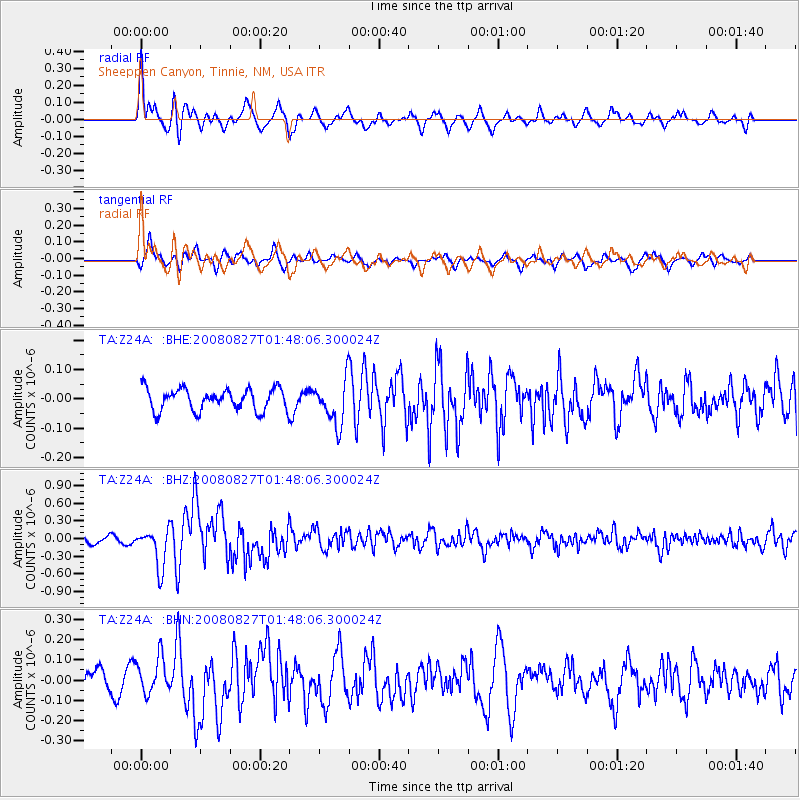
Signal To Noise
| Channel | StoN | STA | LTA |
| TA:Z24A: :BHZ:20080827T01:48:06.300024Z | 7.240224 | 3.3282265E-7 | 4.596856E-8 |
| TA:Z24A: :BHN:20080827T01:48:06.300024Z | 2.0670497 | 8.815935E-8 | 4.264984E-8 |
| TA:Z24A: :BHE:20080827T01:48:06.300024Z | 2.067609 | 7.676103E-8 | 3.7125506E-8 |
| Arrivals |
| Ps | 2.4 SECOND |
| PpPs | 7.8 SECOND |
| PsPs/PpSs | 10 SECOND |


