You are here: Home > Network List > TA - USArray Transportable Network (new EarthScope stations) Stations List
> Station Z24A Sheeppen Canyon, Tinnie, NM, USA > Earthquake Result Viewer
Z24A Sheeppen Canyon, Tinnie, NM, USA - Earthquake Result Viewer
| Earthquake location: |
Hokkaido, Japan Region |
| Earthquake latitude/longitude: |
41.9/143.8 |
| Earthquake time(UTC): |
2008/09/11 (255) 00:20:50 GMT |
| Earthquake Depth: |
25 km |
| Earthquake Magnitude: |
6.1 MB, 7.0 MS, 6.8 MW, 6.8 MW |
| Earthquake Catalog/Contributor: |
WHDF/NEIC |
|
| Network: |
TA USArray Transportable Network (new EarthScope stations) |
| Station: |
Z24A Sheeppen Canyon, Tinnie, NM, USA |
| Lat/Lon: |
33.33 N/105.36 W |
| Elevation: |
1863 m |
|
| Distance: |
81.9 deg |
| Az: |
52.197 deg |
| Baz: |
315.2 deg |
| Ray Param: |
0.04723797 |
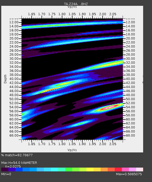
| Estimated Moho Depth: |
54.0 km |
| Estimated Crust Vp/Vs: |
2.03 |
| Assumed Crust Vp: |
6.232 km/s |
| Estimated Crust Vs: |
3.074 km/s |
| Estimated Crust Poisson's Ratio: |
0.34 |
|
| Radial Match: |
92.78677 % |
| Radial Bump: |
327 |
| Transverse Match: |
89.30639 % |
| Transverse Bump: |
378 |
| SOD ConfigId: |
2560 |
| Insert Time: |
2010-03-06 07:28:22.233 +0000 |
| GWidth: |
2.5 |
| Max Bumps: |
400 |
| Tol: |
0.001 |
|
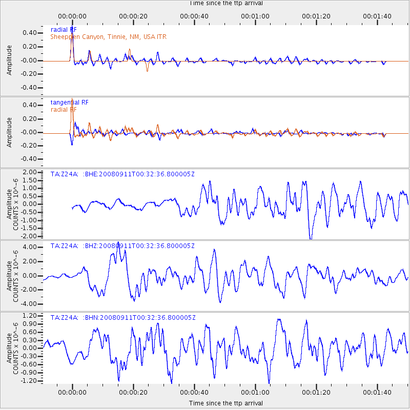
Signal To Noise
| Channel | StoN | STA | LTA |
| TA:Z24A: :BHZ:20080911T00:32:36.800005Z | 1.8984836 | 6.238081E-7 | 3.285823E-7 |
| TA:Z24A: :BHN:20080911T00:32:36.800005Z | 2.261211 | 3.6806907E-7 | 1.6277521E-7 |
| TA:Z24A: :BHE:20080911T00:32:36.800005Z | 1.5748135 | 3.0454353E-7 | 1.9338387E-7 |
| Arrivals |
| Ps | 9.1 SECOND |
| PpPs | 26 SECOND |
| PsPs/PpSs | 35 SECOND |


