You are here: Home > Network List > UW - Pacific Northwest Regional Seismic Network Stations List
> Station WOLL Wollman Farm, Schrag, WA, USA > Earthquake Result Viewer
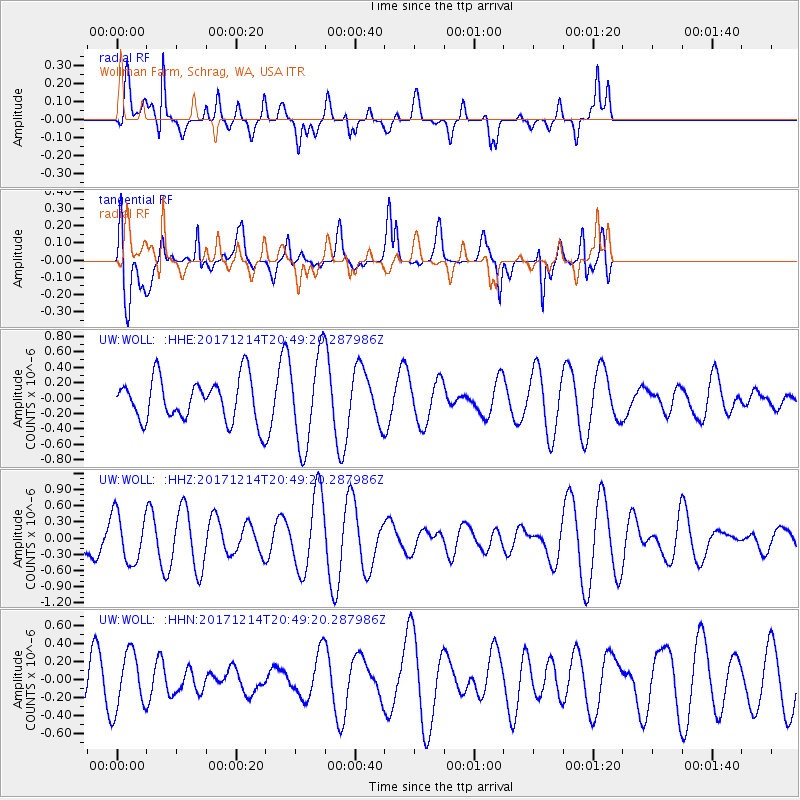
WOLL Wollman Farm, Schrag, WA, USA - Earthquake Result Viewer
*The percent match for this event was below the threshold and hence no stack was calculated.
| Earthquake location: |
Southeast Of Loyalty Islands |
| Earthquake latitude/longitude: |
-21.1/169.6 |
| Earthquake time(UTC): |
2017/12/14 (348) 20:36:36 GMT |
| Earthquake Depth: |
15 km |
| Earthquake Magnitude: |
5.5 Mww |
| Earthquake Catalog/Contributor: |
NEIC PDE/us |
|
| Network: |
UW Pacific Northwest Regional Seismic Network |
| Station: |
WOLL Wollman Farm, Schrag, WA, USA |
| Lat/Lon: |
47.06 N/118.92 W |
| Elevation: |
385 m |
|
| Distance: |
93.4 deg |
| Az: |
40.513 deg |
| Baz: |
242.508 deg |
| Ray Param: |
$rayparam |
*The percent match for this event was below the threshold and hence was not used in the summary stack. |
|
| Radial Match: |
66.820366 % |
| Radial Bump: |
400 |
| Transverse Match: |
73.6501 % |
| Transverse Bump: |
400 |
| SOD ConfigId: |
13570011 |
| Insert Time: |
2019-04-29 10:38:50.904 +0000 |
| GWidth: |
2.5 |
| Max Bumps: |
400 |
| Tol: |
0.001 |
|
Signal To Noise
| Channel | StoN | STA | LTA |
| UW:WOLL: :HHZ:20171214T20:49:20.287986Z | 1.5271815 | 4.5493886E-7 | 2.9789442E-7 |
| UW:WOLL: :HHN:20171214T20:49:20.287986Z | 1.1767008 | 3.1771998E-7 | 2.7000914E-7 |
| UW:WOLL: :HHE:20171214T20:49:20.287986Z | 2.151684 | 5.670302E-7 | 2.6352856E-7 |
| Arrivals |
| Ps | |
| PpPs | |
| PsPs/PpSs | |


