You are here: Home > Network List > TA - USArray Transportable Network (new EarthScope stations) Stations List
> Station Z24A Sheeppen Canyon, Tinnie, NM, USA > Earthquake Result Viewer
Z24A Sheeppen Canyon, Tinnie, NM, USA - Earthquake Result Viewer
| Earthquake location: |
Near Coast Of Venezuela |
| Earthquake latitude/longitude: |
10.7/-67.9 |
| Earthquake time(UTC): |
2009/09/12 (255) 20:06:24 GMT |
| Earthquake Depth: |
10 km |
| Earthquake Magnitude: |
6.3 MB, 6.4 MS, 6.3 MW, 6.3 MW |
| Earthquake Catalog/Contributor: |
WHDF/NEIC |
|
| Network: |
TA USArray Transportable Network (new EarthScope stations) |
| Station: |
Z24A Sheeppen Canyon, Tinnie, NM, USA |
| Lat/Lon: |
33.33 N/105.36 W |
| Elevation: |
1863 m |
|
| Distance: |
41.0 deg |
| Az: |
309.178 deg |
| Baz: |
114.492 deg |
| Ray Param: |
0.07403802 |
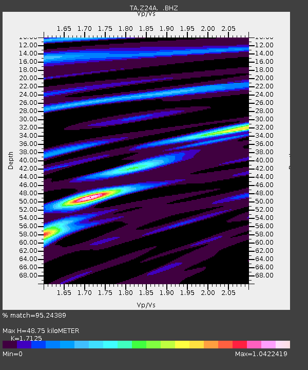
| Estimated Moho Depth: |
48.75 km |
| Estimated Crust Vp/Vs: |
1.71 |
| Assumed Crust Vp: |
6.232 km/s |
| Estimated Crust Vs: |
3.639 km/s |
| Estimated Crust Poisson's Ratio: |
0.24 |
|
| Radial Match: |
95.24389 % |
| Radial Bump: |
213 |
| Transverse Match: |
79.471634 % |
| Transverse Bump: |
400 |
| SOD ConfigId: |
2622 |
| Insert Time: |
2010-03-06 07:28:54.250 +0000 |
| GWidth: |
2.5 |
| Max Bumps: |
400 |
| Tol: |
0.001 |
|

Signal To Noise
| Channel | StoN | STA | LTA |
| TA:Z24A: :BHZ:20090912T20:13:37.24901Z | 5.635725 | 1.1700857E-6 | 2.0761938E-7 |
| TA:Z24A: :BHN:20090912T20:13:37.24901Z | 4.5097327 | 3.6132695E-7 | 8.012159E-8 |
| TA:Z24A: :BHE:20090912T20:13:37.24901Z | 4.251966 | 6.1597336E-7 | 1.448679E-7 |
| Arrivals |
| Ps | 6.0 SECOND |
| PpPs | 20 SECOND |
| PsPs/PpSs | 26 SECOND |


