You are here: Home > Network List > TA - USArray Transportable Network (new EarthScope stations) Stations List
> Station Z24A Sheeppen Canyon, Tinnie, NM, USA > Earthquake Result Viewer
Z24A Sheeppen Canyon, Tinnie, NM, USA - Earthquake Result Viewer

| Earthquake location: |
Santa Cruz Islands |
| Earthquake latitude/longitude: |
-12.6/166.0 |
| Earthquake time(UTC): |
2009/10/07 (280) 23:23:28 GMT |
| Earthquake Depth: |
36 km |
| Earthquake Magnitude: |
5.5 MB |
| Earthquake Catalog/Contributor: |
WHDF/NEIC |
|
| Network: |
TA USArray Transportable Network (new EarthScope stations) |
| Station: |
Z24A Sheeppen Canyon, Tinnie, NM, USA |
| Lat/Lon: |
33.33 N/105.36 W |
| Elevation: |
1863 m |
|
| Distance: |
95.7 deg |
| Az: |
57.262 deg |
| Baz: |
258.8 deg |
| Ray Param: |
0.0406961 |
| Estimated Moho Depth: |
16.25 km |
| Estimated Crust Vp/Vs: |
2.09 |
| Assumed Crust Vp: |
6.232 km/s |
| Estimated Crust Vs: |
2.989 km/s |
| Estimated Crust Poisson's Ratio: |
0.35 |
|
| Radial Match: |
87.383514 % |
| Radial Bump: |
400 |
| Transverse Match: |
82.00746 % |
| Transverse Bump: |
396 |
| SOD ConfigId: |
2622 |
| Insert Time: |
2010-03-06 07:29:13.246 +0000 |
| GWidth: |
2.5 |
| Max Bumps: |
400 |
| Tol: |
0.001 |
|
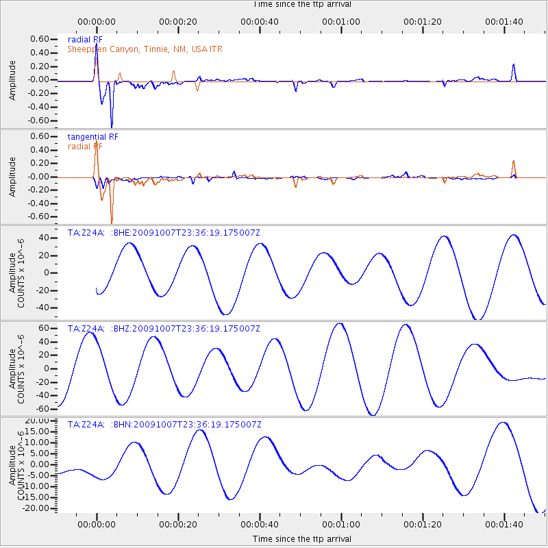
Signal To Noise
| Channel | StoN | STA | LTA |
| TA:Z24A: :BHZ:20091007T23:36:19.175007Z | 0.9564859 | 3.5424815E-5 | 3.703642E-5 |
| TA:Z24A: :BHN:20091007T23:36:19.175007Z | 1.0384195 | 5.818844E-6 | 5.6035583E-6 |
| TA:Z24A: :BHE:20091007T23:36:19.175007Z | 2.0685353 | 4.4527857E-5 | 2.1526273E-5 |
| Arrivals |
| Ps | 2.9 SECOND |
| PpPs | 7.9 SECOND |
| PsPs/PpSs | 11 SECOND |


