You are here: Home > Network List > TA - USArray Transportable Network (new EarthScope stations) Stations List
> Station Z24A Sheeppen Canyon, Tinnie, NM, USA > Earthquake Result Viewer
Z24A Sheeppen Canyon, Tinnie, NM, USA - Earthquake Result Viewer
| Earthquake location: |
Baffin Bay |
| Earthquake latitude/longitude: |
75.4/-72.5 |
| Earthquake time(UTC): |
2009/07/07 (188) 19:11:46 GMT |
| Earthquake Depth: |
19 km |
| Earthquake Magnitude: |
5.9 MB, 5.7 MS, 6.1 MW, 6.0 MW |
| Earthquake Catalog/Contributor: |
WHDF/NEIC |
|
| Network: |
TA USArray Transportable Network (new EarthScope stations) |
| Station: |
Z24A Sheeppen Canyon, Tinnie, NM, USA |
| Lat/Lon: |
33.33 N/105.36 W |
| Elevation: |
1863 m |
|
| Distance: |
44.9 deg |
| Az: |
220.083 deg |
| Baz: |
11.287 deg |
| Ray Param: |
0.071576804 |
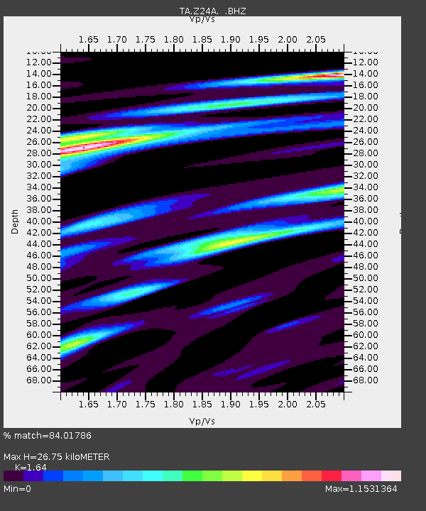
| Estimated Moho Depth: |
26.75 km |
| Estimated Crust Vp/Vs: |
1.64 |
| Assumed Crust Vp: |
6.232 km/s |
| Estimated Crust Vs: |
3.8 km/s |
| Estimated Crust Poisson's Ratio: |
0.20 |
|
| Radial Match: |
84.01786 % |
| Radial Bump: |
400 |
| Transverse Match: |
60.13201 % |
| Transverse Bump: |
400 |
| SOD ConfigId: |
2648 |
| Insert Time: |
2010-03-06 07:29:40.948 +0000 |
| GWidth: |
2.5 |
| Max Bumps: |
400 |
| Tol: |
0.001 |
|

Signal To Noise
| Channel | StoN | STA | LTA |
| TA:Z24A: :BHZ:20090707T19:19:29.548989Z | 8.78252 | 8.1179934E-7 | 9.243353E-8 |
| TA:Z24A: :BHN:20090707T19:19:29.548989Z | 6.607862 | 4.4176065E-7 | 6.6853794E-8 |
| TA:Z24A: :BHE:20090707T19:19:29.548989Z | 0.57897305 | 4.965058E-8 | 8.575629E-8 |
| Arrivals |
| Ps | 2.9 SECOND |
| PpPs | 11 SECOND |
| PsPs/PpSs | 14 SECOND |


