You are here: Home > Network List > AV - Alaska Volcano Observatory Stations List
> Station MAPS Pakushin Southeast, Makushin Volcano, Alaska > Earthquake Result Viewer
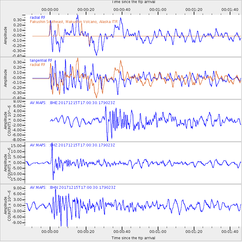
MAPS Pakushin Southeast, Makushin Volcano, Alaska - Earthquake Result Viewer
*The percent match for this event was below the threshold and hence no stack was calculated.
| Earthquake location: |
Java, Indonesia |
| Earthquake latitude/longitude: |
-7.7/108.0 |
| Earthquake time(UTC): |
2017/12/15 (349) 16:47:56 GMT |
| Earthquake Depth: |
92 km |
| Earthquake Magnitude: |
6.5 Mww |
| Earthquake Catalog/Contributor: |
NEIC PDE/us |
|
| Network: |
AV Alaska Volcano Observatory |
| Station: |
MAPS Pakushin Southeast, Makushin Volcano, Alaska |
| Lat/Lon: |
53.81 N/166.94 W |
| Elevation: |
333 m |
|
| Distance: |
93.3 deg |
| Az: |
36.285 deg |
| Baz: |
261.456 deg |
| Ray Param: |
$rayparam |
*The percent match for this event was below the threshold and hence was not used in the summary stack. |
|
| Radial Match: |
63.980488 % |
| Radial Bump: |
400 |
| Transverse Match: |
70.36791 % |
| Transverse Bump: |
400 |
| SOD ConfigId: |
13570011 |
| Insert Time: |
2019-04-29 10:46:54.148 +0000 |
| GWidth: |
2.5 |
| Max Bumps: |
400 |
| Tol: |
0.001 |
|
Signal To Noise
| Channel | StoN | STA | LTA |
| AV:MAPS: :BHZ:20171215T17:00:30.179023Z | 6.9392095 | 6.63356E-6 | 9.559533E-7 |
| AV:MAPS: :BHN:20171215T17:00:30.179023Z | 3.3772898 | 3.6954725E-6 | 1.0942125E-6 |
| AV:MAPS: :BHE:20171215T17:00:30.179023Z | 3.2469854 | 3.763627E-6 | 1.1591142E-6 |
| Arrivals |
| Ps | |
| PpPs | |
| PsPs/PpSs | |


