You are here: Home > Network List > TA - USArray Transportable Network (new EarthScope stations) Stations List
> Station Z24A Sheeppen Canyon, Tinnie, NM, USA > Earthquake Result Viewer
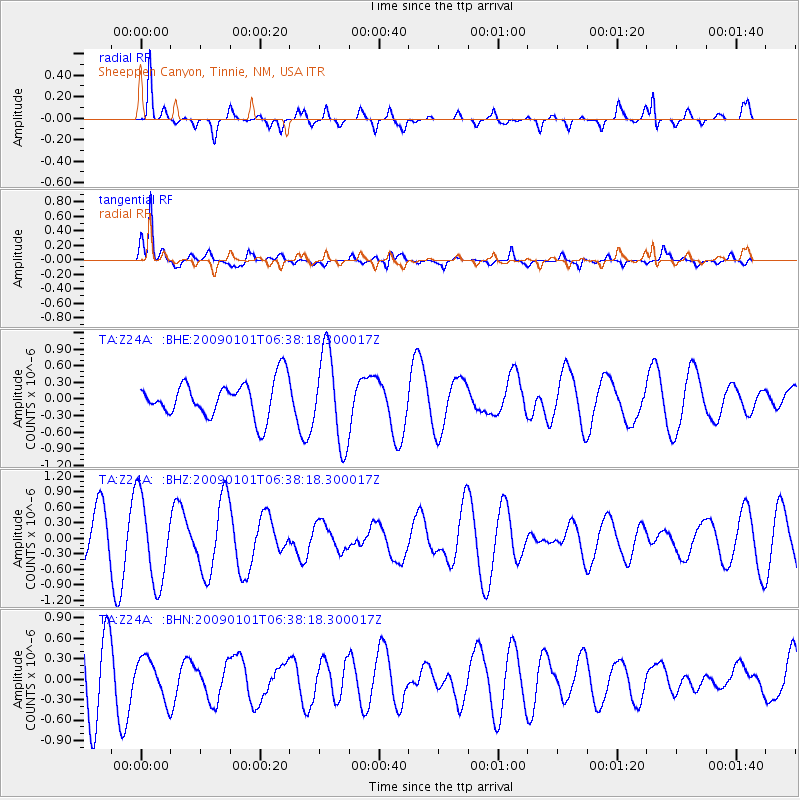
Z24A Sheeppen Canyon, Tinnie, NM, USA - Earthquake Result Viewer
*The percent match for this event was below the threshold and hence no stack was calculated.
| Earthquake location: |
Southern East Pacific Rise |
| Earthquake latitude/longitude: |
-34.8/-107.6 |
| Earthquake time(UTC): |
2009/01/01 (001) 06:27:51 GMT |
| Earthquake Depth: |
10 km |
| Earthquake Magnitude: |
5.8 MW, 5.2 MS, 5.1 MB, 5.8 MW |
| Earthquake Catalog/Contributor: |
WHDF/NEIC |
|
| Network: |
TA USArray Transportable Network (new EarthScope stations) |
| Station: |
Z24A Sheeppen Canyon, Tinnie, NM, USA |
| Lat/Lon: |
33.33 N/105.36 W |
| Elevation: |
1863 m |
|
| Distance: |
67.8 deg |
| Az: |
2.063 deg |
| Baz: |
182.027 deg |
| Ray Param: |
$rayparam |
*The percent match for this event was below the threshold and hence was not used in the summary stack. |
|
| Radial Match: |
77.03423 % |
| Radial Bump: |
300 |
| Transverse Match: |
83.16578 % |
| Transverse Bump: |
350 |
| SOD ConfigId: |
2834 |
| Insert Time: |
2010-03-06 07:29:59.793 +0000 |
| GWidth: |
2.5 |
| Max Bumps: |
400 |
| Tol: |
0.001 |
|
Signal To Noise
| Channel | StoN | STA | LTA |
| TA:Z24A: :BHZ:20090101T06:38:18.300017Z | 2.4024005 | 8.2927056E-7 | 3.4518413E-7 |
| TA:Z24A: :BHN:20090101T06:38:18.300017Z | 0.5520319 | 2.9501652E-7 | 5.3441937E-7 |
| TA:Z24A: :BHE:20090101T06:38:18.300017Z | 2.5153973 | 8.224167E-7 | 3.2695303E-7 |
| Arrivals |
| Ps | |
| PpPs | |
| PsPs/PpSs | |


