You are here: Home > Network List > TA - USArray Transportable Network (new EarthScope stations) Stations List
> Station H16K Elim, AK, USA > Earthquake Result Viewer
H16K Elim, AK, USA - Earthquake Result Viewer
| Earthquake location: |
Java, Indonesia |
| Earthquake latitude/longitude: |
-7.7/108.0 |
| Earthquake time(UTC): |
2017/12/15 (349) 16:47:56 GMT |
| Earthquake Depth: |
92 km |
| Earthquake Magnitude: |
6.5 Mww |
| Earthquake Catalog/Contributor: |
NEIC PDE/us |
|
| Network: |
TA USArray Transportable Network (new EarthScope stations) |
| Station: |
H16K Elim, AK, USA |
| Lat/Lon: |
64.64 N/162.24 W |
| Elevation: |
216 m |
|
| Distance: |
96.8 deg |
| Az: |
25.706 deg |
| Baz: |
266.439 deg |
| Ray Param: |
0.040329643 |
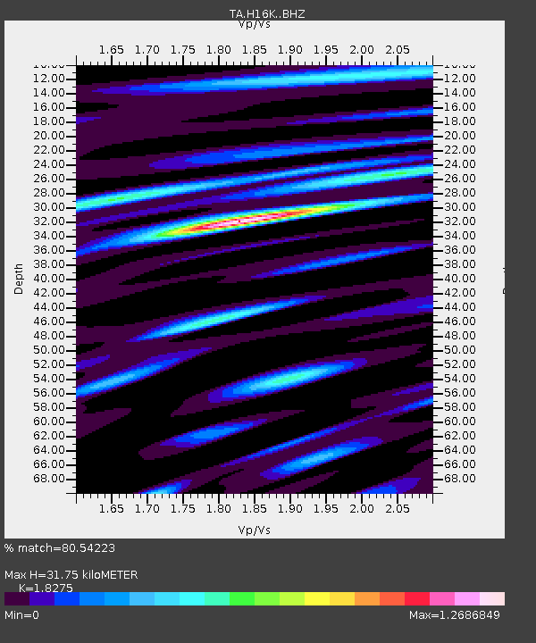
| Estimated Moho Depth: |
31.75 km |
| Estimated Crust Vp/Vs: |
1.83 |
| Assumed Crust Vp: |
6.276 km/s |
| Estimated Crust Vs: |
3.434 km/s |
| Estimated Crust Poisson's Ratio: |
0.29 |
|
| Radial Match: |
80.54223 % |
| Radial Bump: |
400 |
| Transverse Match: |
54.396355 % |
| Transverse Bump: |
400 |
| SOD ConfigId: |
13570011 |
| Insert Time: |
2019-04-29 10:49:01.207 +0000 |
| GWidth: |
2.5 |
| Max Bumps: |
400 |
| Tol: |
0.001 |
|
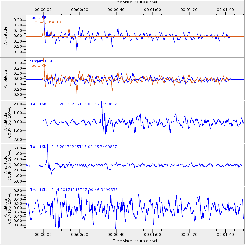
Signal To Noise
| Channel | StoN | STA | LTA |
| TA:H16K: :BHZ:20171215T17:00:46.349983Z | 14.040628 | 2.3342025E-6 | 1.662463E-7 |
| TA:H16K: :BHN:20171215T17:00:46.349983Z | 0.74541664 | 1.9464176E-7 | 2.6111806E-7 |
| TA:H16K: :BHE:20171215T17:00:46.349983Z | 4.3423476 | 8.2597114E-7 | 1.9021303E-7 |
| Arrivals |
| Ps | 4.3 SECOND |
| PpPs | 14 SECOND |
| PsPs/PpSs | 18 SECOND |


