You are here: Home > Network List > TA - USArray Transportable Network (new EarthScope stations) Stations List
> Station Z24A Sheeppen Canyon, Tinnie, NM, USA > Earthquake Result Viewer
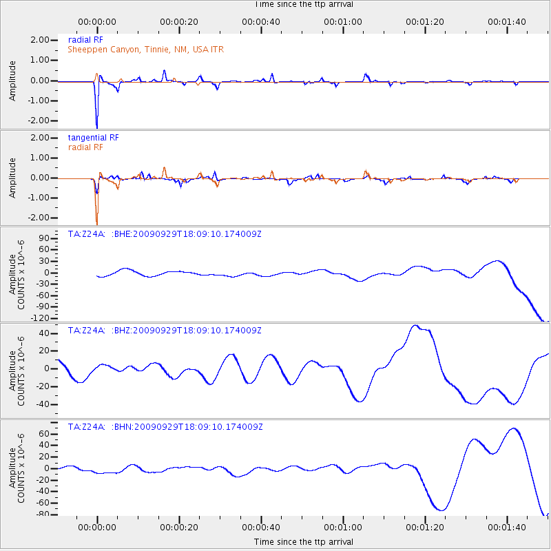
Z24A Sheeppen Canyon, Tinnie, NM, USA - Earthquake Result Viewer
*The percent match for this event was below the threshold and hence no stack was calculated.
| Earthquake location: |
Tonga Islands |
| Earthquake latitude/longitude: |
-15.8/-173.1 |
| Earthquake time(UTC): |
2009/09/29 (272) 17:57:26 GMT |
| Earthquake Depth: |
10 km |
| Earthquake Magnitude: |
5.6 MB |
| Earthquake Catalog/Contributor: |
WHDF/NEIC |
|
| Network: |
TA USArray Transportable Network (new EarthScope stations) |
| Station: |
Z24A Sheeppen Canyon, Tinnie, NM, USA |
| Lat/Lon: |
33.33 N/105.36 W |
| Elevation: |
1863 m |
|
| Distance: |
81.0 deg |
| Az: |
51.688 deg |
| Baz: |
244.446 deg |
| Ray Param: |
$rayparam |
*The percent match for this event was below the threshold and hence was not used in the summary stack. |
|
| Radial Match: |
92.0372 % |
| Radial Bump: |
206 |
| Transverse Match: |
68.499084 % |
| Transverse Bump: |
304 |
| SOD ConfigId: |
2622 |
| Insert Time: |
2010-03-06 07:31:19.096 +0000 |
| GWidth: |
2.5 |
| Max Bumps: |
400 |
| Tol: |
0.001 |
|
Signal To Noise
| Channel | StoN | STA | LTA |
| TA:Z24A: :BHZ:20090929T18:09:10.174009Z | 0.324721 | 3.5705884E-6 | 1.0995865E-5 |
| TA:Z24A: :BHN:20090929T18:09:10.174009Z | 1.9647429 | 6.9946914E-6 | 3.5601054E-6 |
| TA:Z24A: :BHE:20090929T18:09:10.174009Z | 1.0908289 | 7.2645375E-6 | 6.659649E-6 |
| Arrivals |
| Ps | |
| PpPs | |
| PsPs/PpSs | |


