You are here: Home > Network List > TA - USArray Transportable Network (new EarthScope stations) Stations List
> Station Z24A Sheeppen Canyon, Tinnie, NM, USA > Earthquake Result Viewer
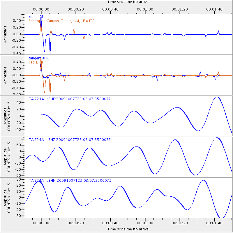
Z24A Sheeppen Canyon, Tinnie, NM, USA - Earthquake Result Viewer
*The percent match for this event was below the threshold and hence no stack was calculated.
| Earthquake location: |
Santa Cruz Islands |
| Earthquake latitude/longitude: |
-12.4/166.1 |
| Earthquake time(UTC): |
2009/10/07 (280) 22:50:15 GMT |
| Earthquake Depth: |
21 km |
| Earthquake Magnitude: |
5.8 MB |
| Earthquake Catalog/Contributor: |
WHDF/NEIC |
|
| Network: |
TA USArray Transportable Network (new EarthScope stations) |
| Station: |
Z24A Sheeppen Canyon, Tinnie, NM, USA |
| Lat/Lon: |
33.33 N/105.36 W |
| Elevation: |
1863 m |
|
| Distance: |
95.5 deg |
| Az: |
57.226 deg |
| Baz: |
258.878 deg |
| Ray Param: |
$rayparam |
*The percent match for this event was below the threshold and hence was not used in the summary stack. |
|
| Radial Match: |
96.383514 % |
| Radial Bump: |
286 |
| Transverse Match: |
83.58572 % |
| Transverse Bump: |
393 |
| SOD ConfigId: |
2622 |
| Insert Time: |
2010-03-06 07:31:26.386 +0000 |
| GWidth: |
2.5 |
| Max Bumps: |
400 |
| Tol: |
0.001 |
|
Signal To Noise
| Channel | StoN | STA | LTA |
| TA:Z24A: :BHZ:20091007T23:03:07.350007Z | 0.3900153 | 1.1073478E-5 | 2.839242E-5 |
| TA:Z24A: :BHN:20091007T23:03:07.350007Z | 2.3530412 | 2.2232683E-5 | 9.4484885E-6 |
| TA:Z24A: :BHE:20091007T23:03:07.350007Z | 0.8078521 | 1.4371831E-5 | 1.7790175E-5 |
| Arrivals |
| Ps | |
| PpPs | |
| PsPs/PpSs | |


