You are here: Home > Network List > UW - Pacific Northwest Regional Seismic Network Stations List
> Station MRBL Marblemount, WA, USA > Earthquake Result Viewer
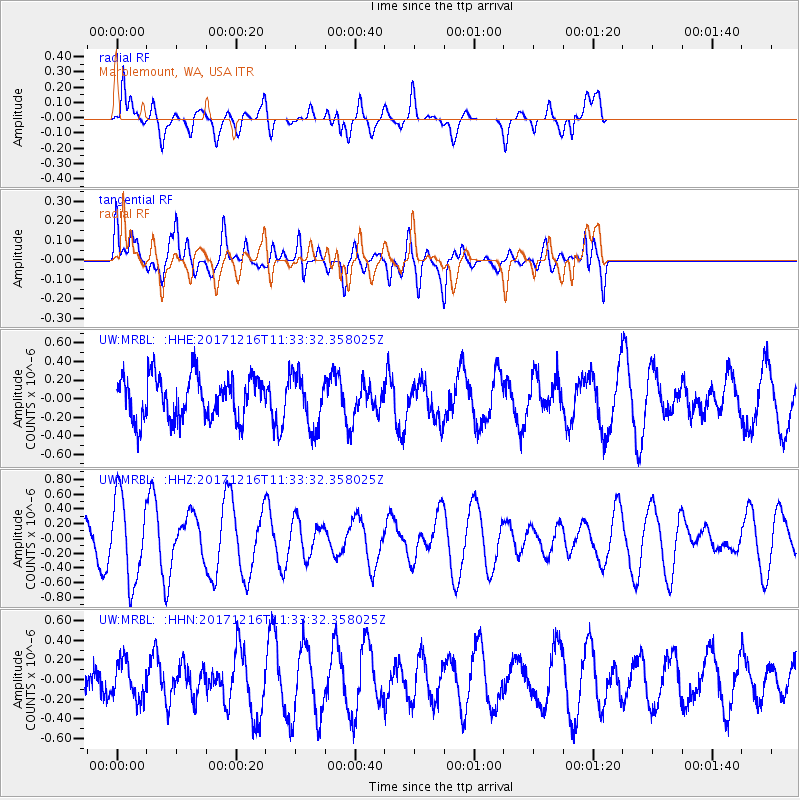
MRBL Marblemount, WA, USA - Earthquake Result Viewer
*The percent match for this event was below the threshold and hence no stack was calculated.
| Earthquake location: |
Fiji Islands Region |
| Earthquake latitude/longitude: |
-17.3/-177.5 |
| Earthquake time(UTC): |
2017/12/16 (350) 11:22:24 GMT |
| Earthquake Depth: |
391 km |
| Earthquake Magnitude: |
5.5 Mww |
| Earthquake Catalog/Contributor: |
NEIC PDE/us |
|
| Network: |
UW Pacific Northwest Regional Seismic Network |
| Station: |
MRBL Marblemount, WA, USA |
| Lat/Lon: |
48.52 N/121.48 W |
| Elevation: |
75 m |
|
| Distance: |
82.3 deg |
| Az: |
33.816 deg |
| Baz: |
233.082 deg |
| Ray Param: |
$rayparam |
*The percent match for this event was below the threshold and hence was not used in the summary stack. |
|
| Radial Match: |
63.067055 % |
| Radial Bump: |
400 |
| Transverse Match: |
35.152676 % |
| Transverse Bump: |
400 |
| SOD ConfigId: |
13570011 |
| Insert Time: |
2019-04-29 10:58:07.878 +0000 |
| GWidth: |
2.5 |
| Max Bumps: |
400 |
| Tol: |
0.001 |
|
Signal To Noise
| Channel | StoN | STA | LTA |
| UW:MRBL: :HHZ:20171216T11:33:32.358025Z | 2.3564117 | 5.659824E-7 | 2.4018826E-7 |
| UW:MRBL: :HHN:20171216T11:33:32.358025Z | 0.75165576 | 1.9193308E-7 | 2.5534706E-7 |
| UW:MRBL: :HHE:20171216T11:33:32.358025Z | 1.2668984 | 2.915401E-7 | 2.3012115E-7 |
| Arrivals |
| Ps | |
| PpPs | |
| PsPs/PpSs | |


