You are here: Home > Network List > CI - Caltech Regional Seismic Network Stations List
> Station EDW2 EDW2, Mojave, CA, USA > Earthquake Result Viewer
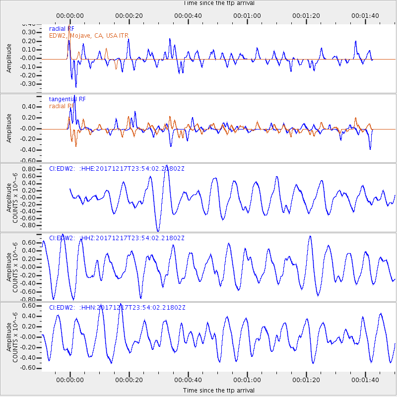
EDW2 EDW2, Mojave, CA, USA - Earthquake Result Viewer
*The percent match for this event was below the threshold and hence no stack was calculated.
| Earthquake location: |
W. Caroline Islands, Micronesia |
| Earthquake latitude/longitude: |
10.0/140.2 |
| Earthquake time(UTC): |
2017/12/17 (351) 23:41:16 GMT |
| Earthquake Depth: |
10 km |
| Earthquake Magnitude: |
5.5 mb |
| Earthquake Catalog/Contributor: |
NEIC PDE/us |
|
| Network: |
CI Caltech Regional Seismic Network |
| Station: |
EDW2 EDW2, Mojave, CA, USA |
| Lat/Lon: |
34.88 N/117.99 W |
| Elevation: |
772 m |
|
| Distance: |
93.9 deg |
| Az: |
53.752 deg |
| Baz: |
284.959 deg |
| Ray Param: |
$rayparam |
*The percent match for this event was below the threshold and hence was not used in the summary stack. |
|
| Radial Match: |
62.32883 % |
| Radial Bump: |
400 |
| Transverse Match: |
83.11178 % |
| Transverse Bump: |
378 |
| SOD ConfigId: |
13570011 |
| Insert Time: |
2019-04-29 11:03:07.512 +0000 |
| GWidth: |
2.5 |
| Max Bumps: |
400 |
| Tol: |
0.001 |
|
Signal To Noise
| Channel | StoN | STA | LTA |
| CI:EDW2: :HHZ:20171217T23:54:02.21802Z | 1.4595186 | 5.164097E-7 | 3.5382195E-7 |
| CI:EDW2: :HHN:20171217T23:54:02.21802Z | 1.0235407 | 2.4436514E-7 | 2.3874492E-7 |
| CI:EDW2: :HHE:20171217T23:54:02.21802Z | 3.6713552 | 6.528303E-7 | 1.7781726E-7 |
| Arrivals |
| Ps | |
| PpPs | |
| PsPs/PpSs | |


