You are here: Home > Network List > TA - USArray Transportable Network (new EarthScope stations) Stations List
> Station E20K Nigu River, AK, USA > Earthquake Result Viewer
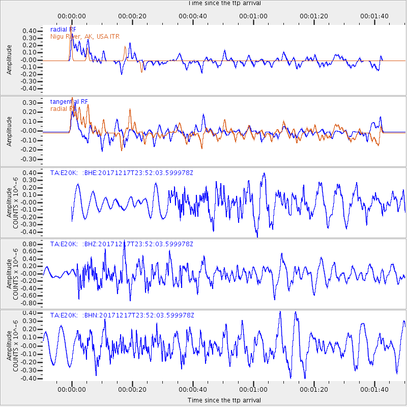
E20K Nigu River, AK, USA - Earthquake Result Viewer
*The percent match for this event was below the threshold and hence no stack was calculated.
| Earthquake location: |
W. Caroline Islands, Micronesia |
| Earthquake latitude/longitude: |
10.0/140.2 |
| Earthquake time(UTC): |
2017/12/17 (351) 23:41:16 GMT |
| Earthquake Depth: |
10 km |
| Earthquake Magnitude: |
5.5 mb |
| Earthquake Catalog/Contributor: |
NEIC PDE/us |
|
| Network: |
TA USArray Transportable Network (new EarthScope stations) |
| Station: |
E20K Nigu River, AK, USA |
| Lat/Lon: |
68.26 N/156.19 W |
| Elevation: |
866 m |
|
| Distance: |
71.1 deg |
| Az: |
20.663 deg |
| Baz: |
248.873 deg |
| Ray Param: |
$rayparam |
*The percent match for this event was below the threshold and hence was not used in the summary stack. |
|
| Radial Match: |
55.21817 % |
| Radial Bump: |
400 |
| Transverse Match: |
58.17505 % |
| Transverse Bump: |
400 |
| SOD ConfigId: |
13570011 |
| Insert Time: |
2019-04-29 11:05:28.831 +0000 |
| GWidth: |
2.5 |
| Max Bumps: |
400 |
| Tol: |
0.001 |
|
Signal To Noise
| Channel | StoN | STA | LTA |
| TA:E20K: :BHZ:20171217T23:52:03.599978Z | 2.4718611 | 2.1845922E-7 | 8.8378435E-8 |
| TA:E20K: :BHN:20171217T23:52:03.599978Z | 1.1455798 | 1.3148721E-7 | 1.1477786E-7 |
| TA:E20K: :BHE:20171217T23:52:03.599978Z | 1.5047306 | 1.440184E-7 | 9.571042E-8 |
| Arrivals |
| Ps | |
| PpPs | |
| PsPs/PpSs | |


