You are here: Home > Network List > TA - USArray Transportable Network (new EarthScope stations) Stations List
> Station Z24A Sheeppen Canyon, Tinnie, NM, USA > Earthquake Result Viewer
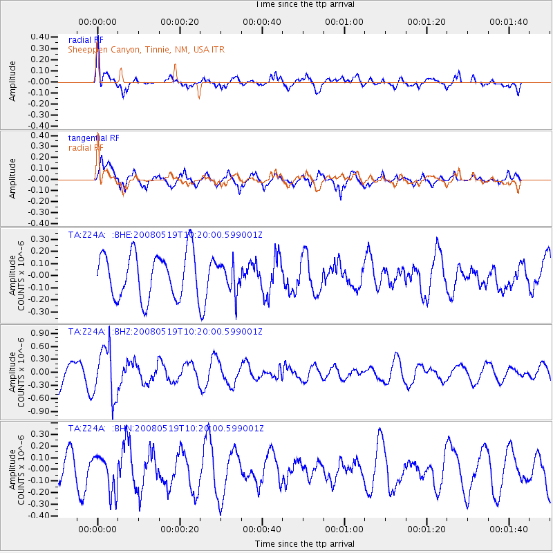
Z24A Sheeppen Canyon, Tinnie, NM, USA - Earthquake Result Viewer
*The percent match for this event was below the threshold and hence no stack was calculated.
| Earthquake location: |
E. Russia-N.E. China Border Reg. |
| Earthquake latitude/longitude: |
42.5/131.9 |
| Earthquake time(UTC): |
2008/05/19 (140) 10:08:36 GMT |
| Earthquake Depth: |
513 km |
| Earthquake Magnitude: |
5.7 MW, 5.4 MB, 5.6 MW |
| Earthquake Catalog/Contributor: |
WHDF/NEIC |
|
| Network: |
TA USArray Transportable Network (new EarthScope stations) |
| Station: |
Z24A Sheeppen Canyon, Tinnie, NM, USA |
| Lat/Lon: |
33.33 N/105.36 W |
| Elevation: |
1863 m |
|
| Distance: |
88.1 deg |
| Az: |
44.782 deg |
| Baz: |
321.523 deg |
| Ray Param: |
$rayparam |
*The percent match for this event was below the threshold and hence was not used in the summary stack. |
|
| Radial Match: |
54.435905 % |
| Radial Bump: |
400 |
| Transverse Match: |
78.99893 % |
| Transverse Bump: |
351 |
| SOD ConfigId: |
2504 |
| Insert Time: |
2010-03-06 07:32:16.943 +0000 |
| GWidth: |
2.5 |
| Max Bumps: |
400 |
| Tol: |
0.001 |
|
Signal To Noise
| Channel | StoN | STA | LTA |
| TA:Z24A: :BHZ:20080519T10:20:00.599001Z | 2.432656 | 5.8504094E-7 | 2.4049473E-7 |
| TA:Z24A: :BHN:20080519T10:20:00.599001Z | 0.9172557 | 1.602609E-7 | 1.747178E-7 |
| TA:Z24A: :BHE:20080519T10:20:00.599001Z | 0.6351337 | 1.1910243E-7 | 1.875234E-7 |
| Arrivals |
| Ps | |
| PpPs | |
| PsPs/PpSs | |


